Larimer County Search and Rescue
Mission Reports 2008
December 28, 2008(Sunday) - Taft Hill Road - Fort Collins - Overdue Male
December 2x, 2008(?) - PENDING - Wyoming - Tracking - Overdue Male /Tracking Leader: Dave Hake
December 7, 2008(Sunday) - Chambers Lake - Missing Male
November 22, 2008(Saturday) - Mount Margaret - Female Bucked From Horse
November 11, 2008(Tuesday) Sand Creek Pass - Overdue Couple in 4WD
November 10, 2008(Monday) - Greyrock Mountain - Lost Female
November 9, 2008(Sunday) - Loveland Lon Hagler Reservoir - Possibly Suicidal Male
October 24, 2008(Friday) - (Dogs)South Dakota Black Hills - Missing Hunter
October 23, 2008(Thursday) - Loveland - Alzheimer's Search
October 23, 2008(Thursday) - Lone Pine Wildlife Area Lost Hunter
October 19 - 20, 2008(Sunday) - Crystal Mountain Lost Hiker
September 23, 2008(Tuesday) - Trap Lake Trail Injured Hiker
September 22, 2008(Monday) - Round Mountain Trail Overdue Hikers
September 20, 2008(Saturday) - Jack's Gulch / Fish Creek Missing Male Black Powder Hunter
September 17, 2008(Wednesday) AM - Estes Park Missing Female
September 16, 2008(Tuesday)- Stub Creek Injured Hunter
September 14, 2008(Sunday) AM - Stove Prairie Missing Students
August 26, 2008 AM(Tuesday) - Albany County, Wyoming Assist
August 24, 2008(Sunday) PM - Overdue Hiker in Cameron Pass Area
August 24, 2008(Sunday) PM - Overdue Fisherman
August 24, 2008(Sunday) AM - Possible missing 79-year-old female
August 20, 2008 PM(Wednesday) - Possible Overdue WW II Airplane Wreck Chasers
August 16, 2008 PM(Saturday) - West Branch Trail Missing 19YOA Hiker
August 13, 2008(Wednesday) PM - Prairie Divide Missing Climber
August 13, 2008(Wednesday) AM - Storm/Palisade Missing Hiker
August 10, 2008(Sunday) - Bobcat Natural Area, Overdue Runner
August 9 & 10 2008(Saturday/Sunday) - Grand County Search Assist
August 7, 2008(Thursday) - Summit County(Quandary Peak) CSRB Search Assist
August 6, 2008(Wednesday) - Blue Lake Trail Overdue Hikers
July 26, 2008(Saturday)Pole Hill Road Overdue Campers
July 26, 2008(Saturday)Rawahs Camp Lake Trail, Hiker Assist
July 23-24, 2008(Wednesday/Thursday)Hells Canyon Search
July 20, 2008(Sunday)Mount Margaret Rescue
July 20, 2008(Sunday)Eiger Road Injury Carryout
July 20, 2008(Sunday)Laramie River Road Overdue Campers
July 16, 2008(Wednesday)East Side of Horsetooth Reservoir
July 15, 2008(Tuesday)Overdue Fisherman Big South
July 13, 2008(Sunday)Prospect Mountain (Estes Park) Search
July 12, 2008(Saturday)Jurassic Park(Estes) Rescue
July 6, 2008(Sunday)Fort Collins Missing Female
July 5, 2008(Sat)Boulder Ridge(near WY) Search
July 1, 2008(Tuesday)Creedmore Lakes Search
June 30, 2008(Monday)Horsetooth Resevoir Family Search
June 26, 2008(Thursday)MM357, Highway 287 Search
June 22, 2008(Sunday)Poudre River Dive Assist
June 15, 2008(Sunday)Lory State Park Carry Out
June 13, 2008(Friday) Creedmoor Lakes SAR Manager Alert Only
June 9, 2008(Monday)Estes Park Alzheimer Search
June 7, 2008 Berthoud Missing Male
May 30, 2008(Friday) Minuteman Drive Carry Out
May 26, 2008(Monday)Soul Shine Rd(FR122) Search
February 9th, 2008(Saturday)Summit County Search Assist
January 12, 2008(Saturday)Bobcat Ridge Natural Area Search
January 12, 2008(Saturday)Cameron Pass Area Search

December 28, 2008(Sunday) - Taft Hill Road - Fort Collins - Overdue Male
1739, SAR manager page requesting contact with O-3 regarding an overdue 17-year-old male with medical concerns dressed in a red t-shirt and jeans. Subject had been dropped off around 1400 by his father to take a walk with his 6-month-old puppy and expected to arrive at their home about three miles away. With the high wind warning and falling evening temperatures teams were requested to respond direct. The concerns were the terrain features in the area and several small ice covered lakes, which might have drawn the teen's attention while on his walk. The subject was located by deputies and reported in safe condition. The team was stood down at 1759.
Duration: 20 minutes
Miles: 5
LCSAR members: 8 responding before stand down page
LCSO-ES: Tony Simons
In-Town-Coordinator: Jim Mines
SAR Manager: Robin Anderson
December 2x, 2008(?) - PENDING - Wyoming - Tracking - Overdue Male /Tracking Leader: Dave Hake
December 7, 2008(Sunday) - Chambers Lake - Missing Male
A missing male from Thornton was last seen on Wedneday, November 19, 2008 as he left for work where he was scheduled to work through Friday, November 21, 2008. He was reported missing to Law Enforcement by his family on Saturday, November 22, 2008 when he had not returned home.
A car was recently reported to the Larimer County Sheriff's Office as having been abandoned about 1 mile up the Laramie River Road from Highway 14. A license plate number was provided and was connected to the missing male. Larimer County Emergency Services was notified about the abandoned car on Thursday, December 4, 2008. Law Enforcement investigated the scene on Saturday, December 6, 2008 and a search of the area was initiated on Sunday, December 7, 2008.
Agencies:
Larimer County Search and Rescue: 13
Larimer County SAR Manager: Mark Sheets
Diamond Peaks Ski Patrol: 5
LCSO Emergency Services: Dave Mosier
LCSO Emergency Services Support: 3
Totals:
Manpower:
Duration:
Man hours:
Mileage:
November 22, 2008(Saturday) - Mount Margaret - Female Bucked From Horse
11/22/2008 Page at 13:36: PLEASE RESPOND TO MM21 CR74E (MT. MARGARET TRAIL HEAD) FOR A FEMALE THAT FELL ABOUT 10FT AFTER BEING BUCKED OFF A HORSE. 25 MIN. WALK FROM TRAILHEAD.
In route we found out it was a 28 YOA female that had taken a fall and the last report was that she was conscious and breathing but not alert. It was a Delta Medical because of a fall more than 6 ft so Northern Colorado Med Evac. (Medical Helicopter service) was activated. Forest service units were attempting to drive in to see if they could gain quicker access to the patient. Redfeather QRT's (Quick Response Teams) were also trying to find ways in.
Before I got to the Boy Scout Ranch road turnoff, Forest 15 was on scene and would be able to drive the subject to an Landing Zone or be the ground contact for Northern Colorado Med Evac. When that was established the SAR Team was stood down at 14:13
Larimer County SAR hours: 15
Larimer County SAR miles: 360
Larimer County SAR members: 10
LCSO Dispatcher: 1
LCSO-ES Specialist: Justin Whitsell
SAR Manager: Dave Hake
November 11, 2008(Tuesday) Sand Creek Pass - Overdue Couple in 4WD
Tuesday 11 November 2008 - County Road 80C - Well, it seemed like a good idea at the time. Monday is a warm and sunny day in Laramie, WY. Later that evening Paul and Amber purchase a used 4WD truck and decide to take it for a drive on the back roads from Laramie to Fort Collins. They depart at about 21:00 to travel Sand Creek Road (Albany County Road 34) which becomes Chimney Rock Road (Laramer County Road 89) to the Cherokee Park Road (Larimer County Road 80C) then to Highway 287 back to Laramie. There is very little residual snow on the roads. Near the intersection of Pearl Beaver Road (Forest Road 169) and Cherokee Park Road their vehicle quits running and they are unable to get it restarted (some sort of mechanical problem). In addition, they are unable to get a signal on their cell phone. They decide to just stay put until morning, and huddle together for warmth -- all of their emergency/survival gear is in their other truck -- they neglected to stock this truck for what was supposed to be a short outing. Fortunately they are wearing heavy clothing and Carhart jackets -- the night is clear and cold.
Tuesday morning, still unable to get the truck restarted, they start to hike back the way they came (west toward Eaton Reservoir) -- it is sunny and warming. When they reach the top of a rise they discover they have weak cell coverage and send text messages to their friend Scott in Laramie, explaining their situation (they have been walking for the past four hours and are not finding any houses) and asking him to call LCSO, which he does at about 09:20. Paul and Amber are unable to give Scott definitive information about where they are located, just their route of travel, and apparently they are unable to connect via 911 -- only texting is getting through. Dispatch requests Scott tell them to return to their vehicle and wait there for LCSO arrival, which he does. Shortly after Paul and Amber begin the return trek to their vehicle some hunters driving the road encounter them and give them a lift back to their stranded truck. The hunters offer to take them back to Laramie, but Paul and Amber say they need to stay with the vehicle to await LCSO arrival.
In the meantime, at 09:23 Dispatch pages Dave Mosier (Ocean 2) and alerts Mountain Deputy Rob Harris (E23), who starts driving several different roads trying to locate the stranded subjects or their vehicle. At 09:39 comes the page for the Duty SAR Manager (George) to call Dave. Since we don't have a definitive location, we agree that 3-4 4WD vehicles from the Team is appropriate, and since the area is potentially huge if the subjects go walking off road, that launching a CAP airplane is prudent. George contacts ITC Jim Mines to get the vehicle teams, and Mark Sheets to pre-alert TVCS to get an aircrew enroute to the airport while George contacts AFRCC to officially request CAP's participation, and then George heads out to meet the Team at the Cache.
While enroute, AFRCC calls to open mission number 08M-2080A at 17:46Z (10:46 MST). During his conversation with AFRCC, George hears radio traffic that Mountain Deputy Earl Fawcett (E19) is now driving some of the roads, and that Dispatch just heard from the subjects and reaffirmed they need to return to the vehicle -- they are still on the road, they have not gone cross-country. At this time George does not have all the specifics about the subjects that AFRCC likes to have in their records, so he advises them to contact LCSO Dispatch for those details. While Dispatch and AFRCC are talking, Dave radios to have CAP put on standby for now, since the weather in the area is sunny and clear (in town it is cloudy and chilly and breezy, which is what we expected to encounter in the search area). George contacts Bill O'Connor (TVCS Alert Officer and CAP IC for this incident) to put the aircrew on stand-by at the airport (pilot Gary Thomas, observer Dick Hamilton, scanner Ken McNaught in aircraft 2CP).
At the Cache the ten Team members (Robin Anderson, Dick Borowski, Doug Grimm, Dave Hake, Logan Heath, Sandy Jordan, Chris McNerney, Jose Negron, Jake Udel and his dogs, and George) assemble into five 4WD vehicles (including Truck 10) and at 11:15 depart the Cache. Three minutes later, at 11:18, Dave Mosier radios that he has met up with the subjects at the intersection of Forest Road 169 and County Road 80C, and to stand down all resources. George asks Dispatch to contact AFRCC while he contacts TVCS to stand down the aircraft.
Mission AFRCC 08M-2030A is closed at 18:57Z (11:57 MST).
At 11:34 Dave Mosier transports Paul and Amber to Tie Siding, WY to meet up with a friend who will take them back to Laramie.
All units are clear at 13:15.
Mission duration: 2 hours
Larimer County SAR members: 12
Larimer County SAR hours: 24
Larimer County SAR miles: 200
Civil Air Patrol personnel: 5
LCSO-ES Specialist: Dave Mosier
LCSAR SAR Manager: George Janson
November 10, 2008(Monday) - Greyrock Mountain - Lost Female
The weekend hike up to Greyrock was a bust -- and 28 year old Megan felt maybe she was the one who had held the group back, preventing them from reaching the summit. Monday dawns cool and partly sunny, contrary to the forecast of rain or snow mix -- a good day for a hike. She discusses her plan with her good friend Connie, who is unable to accompany her, though Connie does advise Megan to bring her cell phone, and she does so. Megan feels the need to restore a semblance of self-confidence, and at about 11:00, carrying a small day pack, she heads up the trail on a solo quest for the summit of Greyrock. Success -- she reaches the summit a couple hours later! After descending from the rock itself and dutifully following the trail cairns around the northeast face, Megan somehow loses sight of the line of cairns, and continues downhill in search of the next one. Sometime after 14:00 she begins to feel that she is lost, and calls her friend Connie to say she is having trouble finding the trail, but that she is OK and will continue onward. Unfortunately she is unable to find any more cairns or anything that resembles a trail, and again calls Connie to say that she is lost. Connie calls the Sheriff's Office to report that Megan is lost and needs help. Then Connie calls another friend Becky, who advises her to have Megan stay put and have Megan call 911 herself so that the 911 system could pinpoint her location. Connie does so, and at 14:48 Dispatch pages the on-call ES Specialist, Tony Simons. Tony calls Megan and spends nearly half an hour asking numerous questions to try to establish where she might be in an effort to get her to regain the trail, to no avail. By then Megan is feeling a bit scared, especially when Tony tells her that it would be at least two hours before any of the SAR team will be at the trailhead, but she agrees to stay where she is -- at least she has good cell coverage. Unfortunately, T-Mobile is unable to provide accurate GPS coordinates on her phone signal, due to some technological failure in their system -- all their coordinate attempts plot out near I-25, and the one in the 'vicinity' of Greyrock has an error listed at 6000 meters, or over three and a half miles.
At 15:15 came the page for the duty SAR Manager, George, to call Tony. We agree that a small response of 4-6 hasty team members, plus a dog team (just in case) to hike the two trails, coupled with a pair of ATV's coming in from the north via Eagle's Nest Open Space, should be sufficient. To maximize the use of the remaining daylight, we agree a direct, non-emergency, response to the trailhead is appropriate. Since time is of the essence and I am able to leave work right away, I elect to send (at 15:41) the Team page myself, rather than use up time contacting the ITC (Jim Mines) and relaying the resource request; my reasoning being that I would quickly be in my vehicle and on the air to coordinate and cut off the response. Good ol' Murphy throws a few urgent work issues in my face as I am leaving, and giving answers takes many valuable minutes, such that I am a bit behind the power curve. Fortunately, Dave Hake has begun to keep track of the responders so as to effect a cut-off, which helps me get on track quickly. Unfortunately, I don't add correctly, coming up with eight responders (excluding myself), which turns out to be only seven at the trailhead.
Tony arrives at the trailhead at about 16:00, and confirms that Megan's red truck is still in the parking lot. At 16:22 the ATV Team reports they are heading out on the trail from Eagle's Nest. At 16:43 Team 1, Scott Evans and Jim Rabold, head for the summit trail. At 16:49 Team 2, Gilbert Yoh and Marc Smith, head for the meadow trail. At 16:55 Team 3, Dan Fanning with Trace and Sandy Jordan, head for the summit trail. At 17:16 Tony asks dispatch to call Megan and tell her that the SAR team is hiking up the trail, and to listen for horns, whistles and shouts. At 17:34 Team 1 radios that they have passed the upper junction (of summit and meadow trails) and as they drop down the hillside will likely have spotty radio coverage. At about 17:40 rain begins, and lasts about half an hour, long enough to soak into clothing -- we wonder how Megan is faring. Up on Greyrock the precipitation is a snow\graupel mix making the rocks slick. At 17:54 Megan calls dispatch to say she is hearing horns in the distance -- and the dispatcher, Matt, ultimately ends up staying on the line with her for most of the next hour -- a lifeline while she hears the horns and voices wax and wane*^ as Team 1 works to discover where she is located. Fortunately, Megan's cell phone is nearly new, with a fully charged battery, which lasts for the duration of the mission. At about 18:55 Team 1 has direct verbal contact with Megan, though there is a small problem -- a sheer cliff between them and her. Scott asks for two 300 foot ropes, pulleys, anchor gear and tech gear for lowering someone down to Megan's position.
Meanwhile at base Collins Lehman is the last to arrive, and I check with Dave Hake to determine who the eighth person should be -- which is when we discover that all responders have arrived. Fortunately, Sarah Babbitt is listening to her radio, and agrees to respond. By the time she arrives Team 1 is nearing Megan's position, and we hold Collins and Sarah at base. When Scott radios his request for tech gear, they load up and at about 19:30 Team 4 heads out. Fortunately they do not get far, as during this time Team 1 has been exploring other options for getting down to Megan, and they have located a usable route. At 19:34 they radio that they are with Megan, that she is OK, and they are offering her some food and hot liquids -- Team 4 returns to base. By now Teams 2 and 3 have passed the upper junction and hold their positions -- ultimately they rendezvous with Team 1 and Megan for the hike back to base. At 19:55 the ATV Team radios they are back at their vehicle and will soon head back to the Cache. At 20:33 Team 1 radios they have regained the trail, met up with Team 2 and are hiking out. At 21:56 Team 1 radios that all six Team members and Megan are at the lower trail junction, and at 22:17 they arrive at base.
Despite being stranded in a rocky, cliffy section of the mountainside after dark, Megan stayed put and stayed calm, in large measure due to Matt's continual presence on the other end of her cell phone connection. She should feel comfortable with herself and realize that, in a manner she hadn't expected, she has gained a huge measure of self-confidence.
Becky is Scott's wife -- they are friends of Connie and her husband Peter -- Connie and Peter arrive at base to drive Megan and her truck home -- 10 November 2008 is Scott and Becky's 29th Anniversary -- Becky had called Scott to tell him to go on the mission, they'd celebrate on the weekend -- Scott said at the end of the mission it is one of his best 'feel good' finds -- we need to clone Becky and Scott!
Megan's pack has warm clothing and water and little else -- missing are a headlamp, audible and visual signaling devices, map and compass -- guess what Connie and Peter plan to give Megan for future treks ...
There was a lot of echoing of Team 1's horn blasts and yells off of the northeast rock face of Greyrock such that Megan would sometimes think they were getting close, then suddenly they were farther away -- having Matt in continual contact with Megan via cell phone and with Ops via channel 4 (Firenet) helped explain the situation to Megan and keep Team 1 progressing toward Megan's location. However, one learning point is that we (Ops and IC) should have had Team 1 go direct with Dispatch on Firenet, as opposed to us relaying and coordinating between Firenet and SAR-2 channels. This would have also necessitated that Teams 2 and 3 scan Firenet to keep abreast of Team 1's progress. And the ever-present Murphy threw in a grass fire in Glacier View, which complicated our use of Firenet until that small fire was extinguished, because all the fire responders were unable to switch their incident to PVH North channel.
Dave Hake has mapped where we've found hikers in the Greyrock area over the past several years, showing this find within a few hundred feet of another one that also had cell coverage -- a known good spot for such communication if we (LCSAR) need it up there. In addition, when Team 1 was on the slope above Megan, they could see and hear the ATV's below and to the northeast of them, and the ATV operators could see Team 1's headlamps, yet Megan in her location (13T 0475671 4507215) could neither see nor hear the ATV's. The ATV's reached the vicinity of the SW1/4of SW1/4 of Section 19 -- their GPS was intermittent in the vicinity of Greyrock, so we do not have a fix on their actual end point.
Larimer County SAR hours: 80
Larimer County SAR miles: 500
Larimer County SAR members: 10
Larimer County Support Group: 2
LCSO Dispatcher: 1
LCSO-ES Specialist: Tony Simons
In-Town Coordinator: Dave Hake
SAR Manager: George Janson
Map courtesy of George Janson
November 9, 2008(Sunday) - Loveland Lon Hagler Reservoir - Possibly Suicidal Male
Duty SAR Manager page at 20:28 to call Dave Mosier.
LCSO deputies had been looking for the past 1.5 hours for an 18 year old male who had left his home, which is in the vicinity of Lon Hagler Reservoir. Family members reported he was possibly suicidal, likely by taking pills, and they thought there was a possibility that he might have a knife with him, and also that he was barefoot, and unknown if he was under the influence of any drugs or alcohol. LCSO vehicles were at the corner of County Roads 16 and 23, but Dave preferred that any LCSAR resources that responded would stage at the south parking lot for Lon Hagler, which is on the north side of County Road 16 between County Roads 21 and 23.
Dave and I discussed the issue of the subject possibly having a knife - unknown what type or size of knife - and that the page for resources would note this and that we would have a deputy assigned to each field team. We agreed that one or two dog teams and one or two tracking teams would be all we'd field for now.
I then called Dispatch to have them page for the ITC, and the dispatcher told me that the subject had just called home from a 7-11 and deputies were enroute to confirm that it was indeed the missing male, and that she had not yet paged this information to Dave Mosier, so we decided to not send out the page for the ITC. I then called Dave and gave him the update, and he would page the stand-down to the SAR Manager group when the deputies confirmed the person's identity. The stand-down came minutes later at 20:45.
Larimer County SAR hours: 0.25
Larimer County SAR miles: zero
Larimer County SAR members: 1
LCSO-ES Specialist: Dave Mosier
In-Town Coordinator: Jim Mines
SAR Manager: George Janson
October 24, 2008 - South Dakota Black Hills - Missing Hunter
At 22:10 on 10/24/08 we had a request from Randy Maddox of the South Dakota Office of Emergency Management for search dogs for a search in the Black Hills. This was a mission being run by Pennington County which is in the Rapid City area. They were looking for a hunter who had been out three days. They had only found his vehicle on 10/24. They flew a helicopter with infrared that night. A trailing dog had worked on 10/24. The terrain was mountainous and was rough and steep. The weather was in the 50's and 60's with a cold front expected on 10/26.
I got approval from ES and SM and contacted CSRB for out of state response. I spoke with Barry Mitchell and he was communicating the deployment of our resources at the state level. Robin Anderson was available to go and they were arranging a CAP flight for her to leave at 10:00 on 10/25. At 09:00 we received messages that the subject was found and we were stood down. I contacted Randy Maddox and learned that the subject was deceased and they suspected a possible heart attack as the cause.
Dan Fanning
October 23, 2008 - Loveland - Alzheimer's Search
The SAR team was paged to respond direct to the home of a missing Alzheimer's patient in Loveland. As resources were arriving a neighbor approached and stated that they took a woman that appeared to be in distress to the hospital. LCSO Dispatch verified with the hospital that the woman was indeed the one that was reported missing. The team was stood down. Agencies: Emergency Services: 2 Larimer County Search and Rescue: 12 LCSO Deputies: 4 Larimer County Park Rangers: 2
October 23, 2008 - Lone Pine Wildlife Area Missing Hunter
At 2038 hours LCSAR was paged out to respond to a search for an overdue hunter in the Lone Pine Wildlife Area.
While we were en route the missing hunter showed up at the trail head. He was OK.
We were stood down at 2330 hours.
Agencies:
Emergency Services: 2
Larimer County Search and Rescue: 15
Emergency Services Support: 2
Duration: 3 hours.
October 19 - 20, 2008 - Crystal Mountain Lost Hiker
First Ops - (Mark Sheets)
October 18, 2008 - Crystal Mountain - Overdue 76 YO Male Hiker
Duty SAR Manager: Mark Sheets
At 18:56, the SAR Manager was paged to call the S-17 reference a missing 76 YO Male hiker overdue in the Crystal Mountain Area. The new SAR Command Trailer had just gotten put into service (by mere minutes no less) so this would be the first mission to be ran out of the new, fully commissioned command post.
The overdue hiker is from the Dallas, TX area and had joined his brother and other family members who were staying in their private cabin and planning to hunt big game the ensuing week. The hiker had arrived the day before (Friday) and went for a short hike alone and returned to the cabin sometime later. He had hunted the area for 22 years and according to the brother (the reporting party), he knew the area quite well.
The RP stated that the missing subject set out at 08:30 wearing jeans, a vest and an orange hat with no other provisions on Saturday for a few hours of hiking with the intent to be back in time for lunch. When he didn't show up, the RP got help from others in the area to go look for his brother. At 18:00, unsuccessful in locating the missing party, they decided to notify Larimer County Sheriff's Office of the situation.
LCSO-ES along with SAR and Support Team members with ATV's responded with the truck and trailer. Trackers and Dogs searched the area to the East of the cabin, the direction where the RP stated the missing subject was last seen hiking at 08:30. Trackers found possible prime sign of the subject some distance to the East but the tracks were later speculated to most likely be from the subjects previous day's hike. Oddly, no other tracks were located. The Dog teams worked to the East but eventually doubled back to the cabin, probably from the previous day's hike as well (speculating).
Weather was fairly decent through the night with a bit of frost felt around 03:00. Considering the data and unable to elicit a response from the missing subject, we feared for the subject's welfare. The weather forecast was calling for a "Hard Freeze" with snow and sleet in the next 36 hours. It became evident that a 2nd operational period would be necessary.
FIRST OPERATIONAL PERIOD STATISTICS
1 ES Sergeant
13 LCSAR members
2 LCSO-ES Support Team members
810 miles driven
82 hours expended
Sunday, October 19, 2008 - Crystal Mountain - Lost Hiker - 2nd Ops
Searchers, trackers, dog teams, and ATV teams continued to search for the missing hiker. Areas searched the night before continued to be covered during the daylight hours. Trackers and dog teams concentrated on areas of interest in order to determine a direction of travel.
Local residents and hunters in the area were notified that a person was missing. They were requested to keep an eye out for someone who appeared lost and to notify us if the person was found.
The search area was also expanded to incorporate other areas of interest that were not covered during the first operational period.
A helicopter arrived at 1400 hours to search a wider area from the air in an attempt to locate the missing subject.
During the second operational period, we did not pick up any additional clues as to the whereabouts of our missing subject.
The mission was suspended at dark. Resources were going to be brought in for a third operational period on Monday, October 20, 2008.
Agencies:
Emergency Services: 1
Larimer County Search and Rescue: 21
Emergency Services Support: 2
Colorado Air Guard Helicopter: 2
Duration: 12 hours
Man Hours: 288
Third Ops (beginning 0630 hours on Monday, Oct. 20)
As of mid-afternoon Oct 19 (Sunday) the subject had not yet been located. A 3rd operational period was then scheduled for the following day. The planning meeting for 3rd ops occurred at 1730 hours on Sunday, Oct. 19. At the planning meeting, it was decided to make a request through CSRB for additional resources.
Briefing occurred at the SAR cache at 0630 hours on Monday, Oct. 20. Reporting for duty were dog teams from FRRD and SARDOC, and foot teams from Douglas County, Arapahoe Rescue, RMRP, El Paso County, Larimer County SAR, Diamond Peaks Ski Patrol, and Rocky Mountain Trackers. Over 50 SAR personnel were involved and fielded in the 3rd ops.
The focus of the third ops plan was East of ICP. This was based on the limited clues that were available, i.e. that the last seen point was on a road East of the party's cabin and foot prints were found East of the cabin. 14 teams were fielded during the early stages of 3rd ops, including foot teams, tracking teams, ATV riders, and dog team. Due to weather conditions, flight support was not feasible.
Shortly after 1200 hours, command reported that a private party had contacted dispatch and claimed to have located the subject. The subject, however, was denying his identity, but the party who located him had looked at the subject's ID and confirmed his name. The subject was brought to ICP where he was greeted by dozens of searchers and family members. He returned with nothing but the clothes on his back, and a walking stick. The subject was of the belief that he had been gone only a couple hours, not over 2 days. The subject seemed mentally sharp, and in good physical condition. From looking at him, one would never have guessed that he spent two nights out in the cold and wet. The mission was stood down about 1230 hours, and all resources returned to the SAR cache by approximately 1600 hours.
Statistics for the 3rd operational period only:
SAR responding: 55
Larimer County Search and Rescue (17)
Douglas County SAR (4)
Arapahoe Rescue (20)
Diamond Peaks (3)
Rocky Mountain Rescue Group(4)
El Paso County SAR (2)
Front Range Rescue Dogs(3)
SARDOC (2)
SAR hours: 660 hours
SAR miles: 1200 miles
ES/Command: Kevin Johnston (S17)
ITC: Amy H. (L23)
SAR manager: Allen W. (L41)
Tracking Report:
For the trackers on the team and for those who were wondering if the print they found was his. It looks like it's his print alright!It also looks to be old enough that it could have been from Saturday. note some of the bruising has turned black.(Dave Hake)


September 23, 2008 - Trap Lake Trail Injured Hiker
Tuesday 23 September 2008 -- Trap Lake Trail, Neota Wilderness -- The day dawned clear and blue sky, temperatures rising quickly into the 60's then the 70's by afternoon -- a perfect day for two Poudre Wilderness Volunteers, Jan and Diane, each fifty-something, to check out the condition of one of the little used trails in the county, Trap Lake Trail off the Long Draw Road up the Poudre Canyon. The trail is 3 miles one way, with about 950 feet of elevation gain, to the edge of the Neota Wilderness, where it (and PWV's patrol of it) ends and gives way to trailless travel within the wilderness. Just over a mile into the trail is a crossing for a small stream, which Jan crosses easily, and continues on. Diane, unfortunately, slips on a piece of wet log submerged in the stream and falls hard, partly into the water, hearing a 'crack' simultaneously with feeling sharp pain in her left ankle. Jan comes back to assist Diane getting out of the water and to a 'comfortable' resting spot. Diane cannot put weight on her leg when standing. In another unfortunate turn, both ladies left home without bringing a packset radio with them -- and the closest phone is the emergency phone at mile marker 77 in the Poudre Canyon, about 12 miles away. After helping Diane shed the wet clothes and getting her bundled into additional clothing to keep her warm, Jan sets off for their vehicle and the phone -- it is now about 13:30.
At 14:02 comes the page for the Team to respond emergent to the scene. Dispatch uses addresses and county road numbers when giving locations, and the Team mostly uses landmarks and local names -- so there was a bit of confusion and several pages sent, plus radio traffic, before the destination was clarified for all responders. This is where the ITC's really help out on rescues -- getting Team-familiar driving instructions out to the responders. Turnout is light so far, with no Truck 10 drivers yet, so I head for the Cache (I'm on the north end of town already) and meet Jose there. First time I've had the opportunity to drive Truck 10 hot -- it is really quite stable around the turns. A second page is needed to gather sufficient resources for a trail carry.
In the meantime, Jan is waiting patiently but worriedly at the emergency phone. Since it will be at least an hour for ES to arrive, (Sam-17) Kevin Johnston, the on-call ES Specialist, asks that either a Poudre Canyon QRT member or the on-duty mountain deputy (Edward-13) Rob Harris respond to meet with Jan and possibly start in for Diane's location. PVQRT members Steve Hummel and Orin Carney meet Jan at the phone and follow Jan to the trailhead -- the radio traffic regarding this gives responders their first solid information about the ultimate location of the incident. Orin and Jan hike in to Diane's location, bringing blankets to help keep her warm, now that the Sun is lowering behind the trees. At about 15:30, Rob and our Sandy Jordan are the next to arrive at the trailhead, and they also hike in to Diane's location, arriving there at 16:24. Truck 10 is arrival at 15:40, followed at about 16:00 by an ever-increasing supply of Team members who carry in the requisite evac and medical gear.
Diane is in good spirits and resting comfortably, her vital signs within normal ranges. The Team splints her leg, loads her into the litter in a semi-reclining position and heads out on the trail. After Rob and Sandy had given us the preliminary patient assessment, Kevin requested that a PVH ambulance respond non-emergent, expecting that our carry-out duration would be the same as the ambulance's drive time. Well, Murphy was present this day ...
Our ambulance (Med-204) was diverted to respond to an emergency call in Glacier View for an elderly person who fell from a ladder and sustained head injuries -- in addition, MedEvac-1 helicopter was dispatched to this incident. However, no one told us at Trap Park trailhead that our ambulance had been diverted, and when we realized it while listening to the radio traffic, Kevin asked for another PVH ambulance (Med-202) to head our way. And since the arrival of the evac team would now be well before the arrival of Med-202, Kevin requested that a PVQRT ambulance respond to the trailhead. In the meantime, we started one of the larger Team-member vehicles to get it warmed up, in case the evac team was out before the PVQRT ambulance arrived (yet another reason for Team members to leave keys at base).
Well, the PVQRT ambulance arrived ahead of the evac team which was back at base at 18:18 (sunset is at 18:58), so Diane had a nice warm ambulance into which to be transferred. Med-202 made good time up the canyon, and met the PVQRT ambulance at Blue Lake trailhead parking lot (which is straight across Hwy 14 from Long Draw Road) and at 18:55 was enroute to PVH. We had our typical mission debriefing and departed the area, arriving home at about 20:00.
Diane later sent a very nice 'thank you' note to the Team.
Larimer County SAR hours: 84
Larimer County SAR miles: 1500
Larimer County SAR members: 14
Poudre Canyon Quick Response Team: 5
Poudre Valley Hospital ambulance crew: 2
LCSO-ES Specialist: Kevin Johnston
SAR Manager: George Janson
September 22, 2008 - Round Mountain Trail Overdue Hikers
Monday 22 September 2008 -- Round Mountain Trail -- The day dawned clear and blue sky, temperatures rising quickly into the 60's then the 70's by afternoon -- a perfect day for four teens (2 male, 2 female) and one thirty-something male to just drive around and have fun together. Eventually they make their way to the Round Mountain Trailhead, because they enjoy walking the Nature Trail. Today, however, the guys decide to 'check out' the summit trail, and divert onto it during the late afternoon, thinking it would be a short loop trail similar to that of the Nature Trail. Well, now they know better. Ultimately the girls return to the vehicle to wait and wait for the guys. As darkness falls, they convince themselves that a bear has likely attacked the guys, and they need help. Not wanting to walk up on a bear, they decide it would be prudent to drive up the trail -- however, the gate is locked. Not to be deterred, they decide that their compact car would fit between the right-side gate post and a nearby tree -- not quite -- they wedge the vehicle at the rear doors and drop a front tire into a dip, lifting the back end, such that even with front-wheel drive they cannot extricate the car.
Meanwhile, an off-duty Estes Park Police officer (in his personal vehicle) is driving down the canyon and sees headlights at an odd angle in an odd location on the hillside, and drives into the parking lot to investigate. The two girls tell him that their boyfriends had gone on a hike up the mountain (that they have no gear with them, and one went up shirtless) and were overdue in returning, not mentioning that there were actually three guys on the hike, so the officer naturally presumes only two males. Not having a radio, the officer drives down the canyon until he has cell service and reports the incident to LCSO dispatch.
At 21:10 the pager goes off asking the duty SAR Manager to call (Ocean-2) Dave Mosier. Dave and I decide that given the guys have no gear and that the weather is benign, that the guys are likely benighted and thus a small response of six searchers\trackers and a dog to sweep the trail is all that should be needed. Dave heads for the trailhead and I call ITC Amy Ho for paging the Team, then I head for the trailhead. When Dave arrives there are no people to be found, yet there is a vehicle wedged between the gate post and tree. I arrive shortly after Dave, and Team members begin to arrive.
At about this time the guys have reached an area where they can see city lights and find they have cell coverage, so they call 911 to report that they are lost. However, since they'd been using the cell phone all day, the battery power is low, and contact is lost. Over the course of the next hour, dispatch and the males have intermittent contact via the cell phone, and on one occasion the caller says the one guy is experiencing abdominal pains and cannot walk. Now we have a potential rescue once we locate the guys, so Dave asks dispatch to page a direct non-emergency response for Team members for the evac -- so much for our nice walk in the park! And to complicate things further, on one of the calls the caller tells dispatch there are three males in the lost group, and they are burning clothing to keep a fire going (all three are smokers). Dispatch repeatedly tells them to just stay where they are, that searchers are on the way up, and to stay warm ("put another log on the fire").
At about this time a large SUV pulls up to the far end of the parking lot. Two girls and an elderly man emerge, and Dave engages them in conversation -- yes, they are the girls whose boyfriends are hiking the summit trail, and yes, there are three males who went on this hike. The elderly male is the uncle of one of the females and he is there to extricate the stuck car, intending to just pull it out with a tow strap -- the car comes out easily, none the worse for the experience. Turns out that after the EPPD officer left, the girls hitchhiked to Loveland to get the uncle to extricate their car, which is why no one was around when Dave and I first arrived.
As more and more Team members arrive I get the dog team and a large hasty team headed up the mountain (at 22:32), followed soon after by a trail-carry evac team with the litter and wheel plus a fire shovel and a couple extra gallons of water to drown the fire, then hold a small group at base for future use. The trailhead sign indicates this trail is 4.6 miles one way with about 2670 feet of elevation gain, and it is about 02:00 before the hasty team makes voice contact with the lost trio, and also smells the smoke from their fire. They are at the summit of Sheep Mountain, at the end of the trail, with a HUGE FIRE roaring -- about 4 feet by 8 feet in size, with long large LOGS burning (they took dispatch's comment literally!) -- it is so hot that the trio cannot sit close enough to benefit from the warmth. They next tell the hasty team that they found a pipe bomb about 20 feet away at the summit -- yikes! -- which turns out to be simply the summit register -- they had no knowledge that summit registers exist.
The hasty team quickly assesses that the guy with 'abdominal pains' is feeling OK, and can easily walk down the trail, so the litter team readily heads back downhill. The hasty team gives the trio some water and food, and at 02:44 most soon head down the trail, leaving a few folks to somehow make the FIRE safe for the night -- two gallons of water won't do much for this FIRE -- so they spread the logs as best they can, making sure nothing can roll out of the pit, and use dirt and the water to somewhat 'tame' the FIRE. On the trip out discussion reveals the trio thought the trail would loop back to the parking lot, despite the fact that they were continually gaining elevation, just like the Nature Trail (which is not a loop trail either). Despite the coming of night, they continued onward using the light from an iPod to keep track of the trail. When they reached a dead end at the summit, and could see city lights (Loveland), they decided they were lost enough to call for help. By 04:51 the subjects have been debriefed and have gone home, all Team members are back at base, and after our usual mission debriefing we all head home into the budding light of dawn. Dave Mosier did notify the Forest Service about the FIRE on the summit, and a fire crew went up to it later in the daylight.
Larimer County SAR hours: 216
Larimer County SAR miles: 1100
Larimer County SAR members: 24
LCSO-ES Specialist: Dave Mosier
In-Town Coordinator: Amy Ho
SAR Manager: George Janson
September 20, 2008 - Jack's Gulch / Fish Creek Missing Male Black Powder Hunter
SAR manager Alert Only
1159, SAR manager page requesting SAR mgr contact Kevin (S-17) reference an overdue black-powder hunter in the Fish Creek/Jack Gulch area. Subject was a 57-year-old male, visiting from Wisconsin; described as wearing an orange hat, blue jeans and camo, with limited supplies, in the way of water and food. He and the reporting parties had been hunting the area on horseback but the subject had not returned to camp the prior evening. While on the phone with ES the subject was reported as located and code 4 through dispatch.
Emergency Services Personnel: 1 (S-17)
SAR manager:1 (Robin Anderson)
Larimer County SAR hours: 8 minutes
Larimer County SAR miles driven: 0
September 17, 2008 AM - Estes Park Missing Female
0224 hours: Page to SAR manager to contact ES specialist (O3) regarding a missing 17 yoa female.
Per telephone call with ES, subject was 17 yoa female, from Estes Park, who was bipolar, had a fight with her mother, and ran away from the residence. Last seen point was near Griffith Court and Marys Lake Road in Estes Park. Subject was wearing blue jeans and a t-shirt. During the course of the conversation, ES was advised from dispatch that the subject had been located.
0240 hours: stand down page.
Larimer County SAR hours: 0.3 hours
Larimer County SAR resources: 1
ES specialist: 1
Larimer County SAR miles: 0
ES specialist: Tony S. (O3)
ITC: Jim Mines
SAR manager: Allen Weaver
September 16, 2008- Stub Creek Injured Hunter
1343 hours - Initial page to SAR team to respond to Stubb Creek ranger station area, for carryout of injured hunter, on Link/Mcintyre trail.
Various pages sent out by ES regarding whether to respond emergent or not. Three pages sent out to SAR team for additional resources with additional information from ITC re directions.
Initial information was that subject was about 5 miles up the trail from the Link trailhead, with head injuries. Other conditions of subject unknown at this point.
1540 hours - Truck 10 arrival at trailhead. Resources on scene included 7 USFS personnel from Albany County along with sheriff deputy from Albany County. LCSAR resources began arriving shortly thereafter. Reporting parties were at the trailhead. There were two other hunters who had been with the subject and part of his hunting party. They reported that subject was riding a mule. The mule spooked and tried to run between two trees, but the subject could not fit through and was thrown/twisted off of the mule. As he fell he hit is head and was thrown into a tree. He was experiencing lower back pain, nausea when he tried to stand, and a laceration on his cheek. RP said he was 48 years old, 6 foot 3 inches, and 245 pounds. (Another hunter with another party who was also on scene, however, said the subject was probably closer to 275 pounds.)
Based on information available, it was expected to be a 10-12 hour evacuation. Teams began entering the field a little before 1600 hours. Around 1800 hours the first teams reached the subject. While teams were enroute to the subject, ES contacted the Air Force about a possible hoist evacuation. Army helicopter out of Buckley AFB started enroute to the area.
By 1840 hours, the Blackhawk was in the area and lowered a flight medic to the ground to assess the patient for packaging. Subject was packaged and hoisted (in a SKED). 1913 hours subject was in the helicopter and being evacuated to med evac (helicopter) at LZ near ICP. Subject transferred from Blackhawk to the med evac helicopter and transported to MCR. (This was the first SAR mission that ES specialist recalled where we utilized two helicopters at the same time for evac.)
Larimer County SAR hours: 248 hours
USFS: 7
Albany County deputy: 1
Larimer County ES: 2
Larimer County SAR resources: 17
Larimer County SAR miles: 1804 miles
ES specialist: Justin W. (O5) and Dave M. (O2)
ITC: Jim Mines
SAR manager: Allen Weaver
September 14, 2008 AM - Stove Prairie Missing Students
0854 hours on Sept. 14, 2008: non-priority page from ES for SAR manager to contact ES specialist (O2 Mosier) re search.
ES was requesting dogs, trackers & searchers for two missing students from CSU. Subjects had gone up the Old Flowers Road the previous night (entered from the East end near Stove Prairie school), with two full carloads of other students. About 4 miles up the road they set up camp. The entire group was drinking, including the two subjects. The two subjects were last seen around 1900 hours. The rest of the group attempted some attraction that evening, but without success. The following morning (Sun. Sept. 14) the group apparently packed up camp and returned to Fort Collins to contact authorities.
The RP told ES specialist that they did not report the subjects missing the previous night, because they didn't think we could search at night. A more reliable source, however, indicates the group chose not to call 911 because they had been drinking and did not want to get into trouble. It is unknown whether the parties or subjects were underage.
Subjects were a male and female. No clothing description other than they had t-shirts, shorts, and tennis shoes. Not prepared to spend the night in the woods.
SAR manager contacted ITC to page the team for staging. While the page was pending, the subjects called in and stated they had walked out and got a ride to town. ES specialist contacted SAR manager about 0920 hours to stand down.
Total Larimer County SAR resouces involved: 2
Total Larimer County SAR hours: 1.5
Larimer County SAR miles driven: 0
ES specialist: Dave M. (O2)
ITC: Jim M.
SAR Manager: Allen W. (Larimer 41)
I initially got the call from an RA at CSU. He said that the two 18 year olds were freshman who went up with a group of other students camping for the weekend. He had called CSUPD about an hour earlier and still hadn't been called back, he wanted help from SAR. I referred them to Emergency Services. After talking to L1, I was putting the page together and had the RA already securing keys to their dorm rooms to get scent articles. The stood down call came after the missing students made contact with E.S. as they came into cell range.
The students were debriefed and this is what was reported. They said that about an hour before dark the whole group decided to leave camp and hike to the top of a ridge. The couple went up one side and the rest of the group went up the other side. It sounds like the couple followed a drainage that curved off a different path. They couldn't find the top of the ridge so they started downhill. However, they were so far off course that downhill was a completely different direction than they came up. Darkness set in so they built a makeshift shelter and huddled in for a very cold night. The female had a t-shirt and shorts on, the male had jeans and a t-shirt. When day began to break they headed to "the lights of the city". They hiked for several hours, crossed a river and found a road where they got a ride.
The other part of the group returned to camp after never meeting up with the couple shortly after dark. They didn't call for help because everyone had been drinking and they didn't want to get in trouble. Morning came and the rest of camp came down to town, only leaving a broken down car at the camp. The RA is going to put together an outdoor adventures safety evening. He and the other RA's requested a speaker about outdoor safety and what to do when someone is in trouble. I told him I would do the PSAR, I'll run it through the team but I can cover it. We should have been called last night but the students were willing to trade the safety of their friends for not getting a petty offense ticket. I can pretty much guarantee the S.O. wouldn't have written any tickets, the general LE mentality is that kids shouldn't be afraid to call for help for any reason.
Jim
August 26, 2008 AM - Albany County, Wyoming Assist
03:09 a page was sent out for the Search and Rescue Dogs of Colorado (SARDOC) coordinator to call Albany County, WY for missing 3-1/2 year-old male. Amy Ho took the call and arranged for Dan Fanning and Trace and Jacob Udel for support to respond. In the process of organizing search dogs Amy asked the Deputy in charge of the search if Trackers could be of use. They said yes and so she contacted me (David Hake) to organize trackers through Rocky Mountain Trackers (RMT). RMT was able to provide the following certified trackers: Brian Zerbe and Terry Browder trackers from Lusk, WY, Keith Black from Burns, WY (also LCSAR member), Scott Evans, Doug Grimm and myself from Fort Collins. Donna Black from Burns and Shane Burd from Glenrock, WY would respond later in the morning.
Amy ended up putting a page out for Searcher, Trackers and Dogs for the mission to help get more searchers out to help in the search. We had Marc Smith, Jarod Kouma, Jim Rabold and Lee Lang respond. Permission was granted from Emergency Services and everyone went in route.
The subject was last seen around 8:15 on the 25th walking around the corrals at the ranch in which he lived. They thought he started to follow some horse riders as they went down a trail. They didn't think he would go very far. They reported him missing a short time after that since he didn't return. Albany County responded with deputies and searched into the evening. After not having any success, they decided to bring in more resources for the search.
Several members made it to the Ranch located off of Hwy 34 approximately 15 miles SW of Wheatland, WY. When they arrived they were starting to gather information when one of the local teams in the field reported that they found the subject. He ok but was scared, scratched up, muddy and had spent the night in a ravine approximately 3/4 of a mile SW of the Ranch. Around 7:05, the rest of the team members in route were stood down via phone calls from Mark Sheets since he knew most people would be out of pager range.
Thanks everyone for your response!
Larimer County SAR Members: 10
In Town Coordinator:1
Manhours: 55 hours
Mileage: 900 miles
August 24, 2008 PM - Cameron Pass Area Overdue Hiker
SAR Manager on duty: Sarah Babbitt
The last page for the previous almost-search came at 1930, indicating that the fisherman was found and code 4, but that Kevin (S17) was looking into a possible overdue hiker in the Cameron Pass area.
1957: Paged to call Kevin re. this hiker. A man had been dropped off at Brown's Lake Trail on Wednesday. His plan supposedly was to hike to Corral Creek, then up Long Draw Road toward La Poudre Pass/Thunder Pass area, then out the Michigan Ditch trail to Cameron Pass. He and his son had done this circuit last year. He was due out Sunday at 1430.
The hiker was from Fort Collins, age 44, no medical issues, obviously was prepared to be out. The RP (his wife) was going to go back up to Cameron for a while, then back home, then would go back up in the AM. If she didn't connect with him then we'd start a search.
This plan covered a lot of ground, so Kevin and I were talking about needing a couple of radio relays as well as putting searchers in at several points: Brown's Lake, Corral Creek (we were going to try to get info from the son on whether the plan was to get there via Mirror Lake/Comanche or the Old Flowers Road), end of Long Draw Road, and Michigan Ditch at Cameron Pass.
I had contacted ITC Amy Ho to start getting folks for the AM if needed. She was not near a computer so she contacted dispatch to put out the page. The folks at dispatch said they had just received a call from the man they thought was this hiker, and Kevin was looking into it, so we held off on the page to the team. Shortly thereafter (2028) the page came out that it was, indeed, our guy and he was on the Crown Point road with some hunters and was OK. They were going to help him meet up with his wife.
It turns out that he had said to his wife as she dropped him off, "I'll meet you at the same place on Sunday." She thought 'the same place' was where they came out last year, but he meant 'the same place as where you are dropping me off right now. 'Big difference! He had gone to Brown's Lake, Mirror Lake, Hourglass Reservoir, and back to Brown's Lake and out, rather than the circuit he'd done last year with his son. So Kevin had a little chat with him about leaving a detailed, written itinerary when he goes hiking next time.
Personnel involved:
Emergency Services Specialist:1 (S17)
SAR Manager:1 (Babbitt)
ITC:1 (Ho)
Mieage: 0 miles
Duration: 30 minutes
August 24, 2008 PM - Phantom Canyon Overdue Fisherman
On call SAR Manager: Sarah Babbitt
SAR manager page at 1919, to call Sam 17 (Kevin Johnston of Emergency Services) re: a lost fisherman in the Phantom Canyon/Halligan Reservoir area.
Kevin had a report of an overdue 30 yoa fisherman. The fisherman had not rejoined his companions at 6:30 PM as planned, and one friend had been farther downstream than the missing man but had not seen him as he had backtracked to the meeting place. The missing fisherman is from Arvada, and has type 1 diabetes. He had insulin with him, but they were not sure if he'd eaten since around 1 PM (and the RP was not sure if he had any food with him).
Phantom Canyon is part of a Nature Conservancy property, which adjoins several other large private properties. The area ranchers and the Nature Conservancy have joined together to create a large fenceless area, as part of a natural corridor running from the mountains to the plains. Phantom Canyon itself is rugged and remote. The trail crosses the North Fork of the Poudre several times, and heads south toward Halligan Reservoir. He was last seen on the north side of the river. The river has a “moderate” flow at this time, and there are no bridges.
Phantom Canyon is accessed by going north on 287 to an unmarked gate (on the west side) several miles north of Livermore. (It's worth the trip if you can get in----the Nature Conservancy limits the numbers of people there at any one time, but they offer great guided walks and volunteer opportunities!)
1928: I paged ITC Amy Ho, to get searchers started.
1930: The SAR manager group received a stand-down page for the fisherman. He was with his friends and Code 4 (OK). But the page also said that Kevin was now investigating a possible lost hiker in the Cameron Pass area and would call me directly when he had more information (see next mission report)!
Emergency Services Specialist:1 (S17)
SAR manager:1 (Sarah Babbitt)
ITC:1 (Amy Ho)
Duration: 20 minutes
Mileage: 0
August 24, 2008 AM - Livermore Possible missing 79-year-old female
On-duty SAR manager: Sarah Babbitt
First SAR manager page came out at 1139, while a group of us were on Duncan's Ridge for the vertical operations field training.
Edward 13 (Deputy Rob Harris) was reporting that a 79 year old woman was unaccounted for at her home northwest of Livermore, on County Road 76H. Her car was at her home, but she was not there. She has a heart condition. It was thought that perhaps she had gone for a walk on her property and gotten into trouble. The terrain there is not terrible, but there are some arroyos and streams and it is not flat.
We started the process of getting a small group of searchers, trackers and dogs together---we were going to have the dogs and trackers respond direct to her residence (to get them going with fewer possible extra scents and tracks) and have the rest of the group stage at the cache then go up.
As ITC Amy Ho was putting out the first page to the SAR team county dispatch put out the page that the subject had been found and was ok. Dispatch's page went out just prior to Amy's page, so the team got the stand-down before knowing there was even a search in the works.
We were stood down at 1203.
For those who are not sure where County Road 76H is: If you are heading north on 287, you drive north past The Forks at the intersection of 287 and 74E (the Red Feather Lakes Road), and 76H is your next left off of 287. It heads roughly west from there until it intersects with CR37 (which runs from 74E to the Cherokee Park road (the latter of which is also CR80C)).
Resources involved:
LCSO Sheriff Deputy:1
Emergency Services:1
LCSAR SAR Manager:1
LCSAR In-Town-Coordinator:1
Duration: 25 minutes
Mileage: 0 miles
August 20, 2008 PM - West of Fort Collins Possible Overdue WW II Airplane Wreck Chasers
Back to TopSAR Manager on duty: Sarah Babbitt
SAR manager page came out at 2330, to call Ocean 3 (Tony Simons).
We had a report of two hikers (Jerry and Ellen) who had gone to hike "to one of the plane wrecks near Fort Collins" and who were supposed to be home for dinner. The hikers were from Milliken and Evans. The RP was Jerry's wife. They had cell phones but calls were going straight to voice mail.
O3 wanted to give a 'heads up', but also to see if I had more info than he did on the various plane wrecks in the area. I didn't have more info, but I knew that Mark Sheets would so I called him. He was able to give us the lat/Long for the 3 military plane wrecks and 1 civilian wreck in the county. (Check out the web site coloradowreckchasing.tripod.com for more info on these.)
When I got back in touch with O3, he had further info from a friend who said he'd thought it was supposed to be an over-night trip. Also, some Weld County deputies were on their way to the hiker's homes to see if they could figure out what vehicle they had taken. They are 'experienced' hikers who would have extra clothes, etc., with them, as well.
We established that they had one of two possible vehicles, and talked about where you access the various trails to these plane wrecks. Because the night was calm and they were probably relatively prepared, and with no known medical issues, the plan was for Tony to head up to the Pingree area to start looking for their vehicle about 0500.
0010: I sent a page to the tactical group to give the basic information and let them know we were on stand-by (Since the tactical group had been awakened by the initial page, it's nice to let everyone know why.)
At 0413 the page came out that the hikers were back home and OK.
Personnel involved:
Emergency Services Specialist:1
LCSAR SAR managers:2 (Babbitt, Sheets)
Duration: 1 Hour
August 16, 2008 PM - West Branch Trail Missing 19YOA Hiker
Back to Top15:17 SAR managers were page reference missing 19-year-old male last know position was MM6 CR 103 (West Branch Trail Head in the Rawahs). The call came in through Forest Service, to a Deputy, then to Emergency Services so we had some mixed stories but one story was that his camera and keys were found on top of the car and all of his camping gear was in the car. We decided to get up there and find out just what was going on.
Truck 10 was in the process of breaking down from the New West festival booth so they could respond with the truck. We were in the process of getting an ITC to organize searcher, trackers and dogs when information came out over the radio that the subject had been located and was ok. No all team page went out.
1 LCSAR Manager: Dave Hake
1 ES person: Dave Mosier
Mileage: 0 miles
August 13, 2008 PM - Prairie Divide Missing Climber
by Dave H.
On Prairie Divide Road north of Red Feather Lakes, Search for missing 57 YOA Male climber
Approximately 1630 page for SAR manager to call emergency service on call Tony S. 57 year old male from Florida had been camping on property in Glacier view and climbing in the area. His friend lived in the area of his property noticed his camp looked quiet for the last couple days and decided to check some areas that the subject frequented. He located his vehicle and searched the area for a few hours without any luck and called 911. The subject's girlfriend had also reported that the subject had stopped calling her since Sunday and in the past he had been checking in with her almost every day.
Tony and I worked up a plan to take 6 or so members up to secure the vehicle and possibly get a direction of travel before night fall and deploy a few hasty teams. Tony worked on getting phone records or pinging the subject cell phone. The ping wouldn't work because the cell phone was turned off. Records showed that the cell phone number we were given as the subject had made a call around 11:00am this morning. This gave us hope that we would be waiting for him to come walking out from a day hike.
After securing the car and more members arrived, several were scanning the rocky areas likely to be climbed. A person was located from the road about 300 yards away and 200 ft. up the rocks. Teams were deployed to the site and subject was unresponsive and the coroner was called in.
After investigation of the scene the body was transported out with a 300 ft. lower and a carryout.
Agencies:
Larimer County Search and Rescue: 9
Emergency Services: 1
ITC:1 Mike F. (Who was actually handling 2 separate search calls at once!)
SAR manager:1 David H
ES:1 O3 (Tony S)
Totals:
Mileage: 900 miles
Man hours: 54 hours
August 13, 2008 AM - Storm/Palisade Missing Hiker
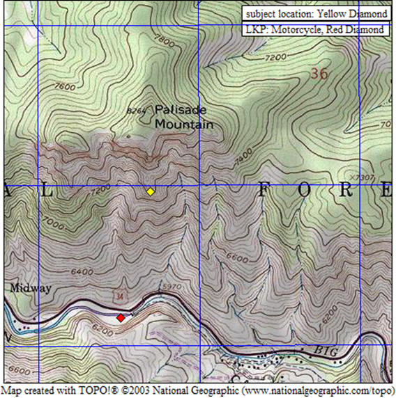
Palisade Mountain, August 13 & 14, 2008 By Robin Anderson - SAR Manager
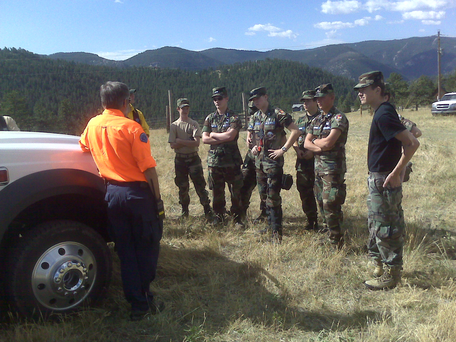
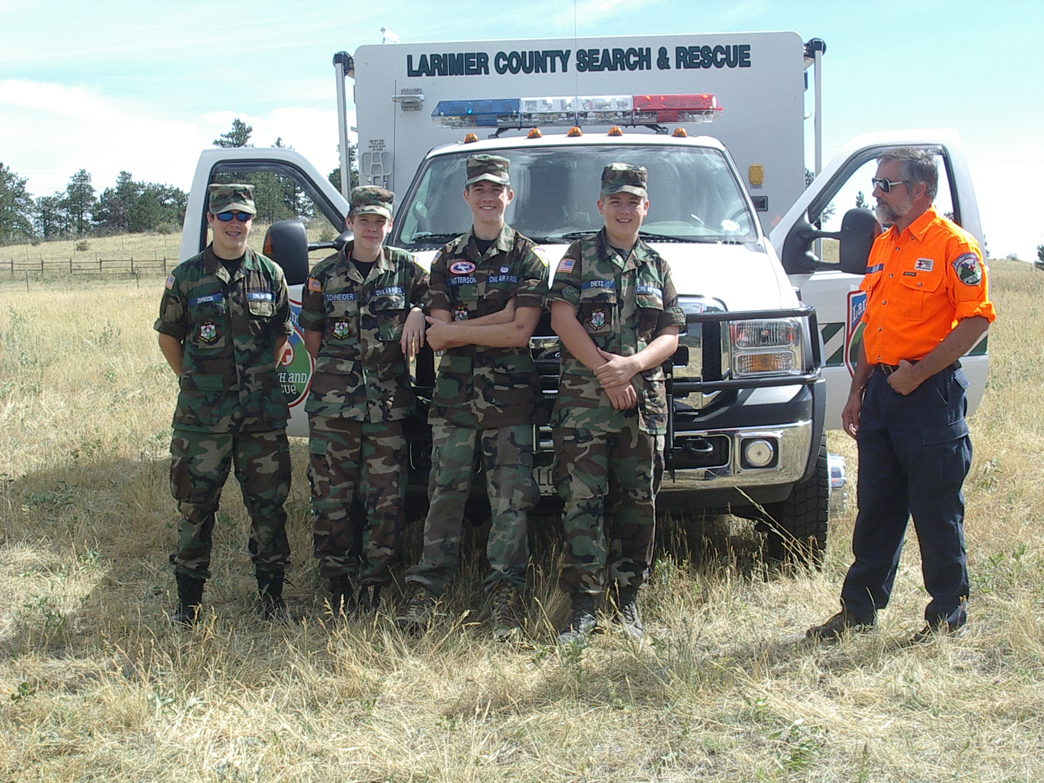
Wednesday August 13, 2008, 0924 initial page requesting SAR manager (Robin Anderson) contact O-5 (Justin Whitesell) reference a missing male, David Price, in his late 40's from Kentucky, last seen on Sunday at the River Forks Inn in Drake Colorado. The subject had mentioned his desire to climb a mountain in Colorado and collect a rock from the top, as memorabilia and the nearby Palisade seem an option. It is thought that the subject began climbing the southern side of Palisade, on Monday, from the Idawild rest area on Hwy 34 where his motorcycle was observed on Wednesday. SAR manager Sarah Babbitt, began the initial staging of teams until Robin Anderson was able to arrive. Seven search teams were fielded for the first operational period, including one tracking team and three dog teams, until 2000 at which time the search was suspended for the night due to the treacherous terrain. A planning meeting was conducted from 1800 to 2200, while additional resources were coordinated throughout the night. A 0500 Thursday morning 1 dog team fielded along the base of Palisade. All other resources staged at 0800 at ICP. Approximately 0922 Army National Guard Helicopter located the subject and a help to direct a hasty team to that location. The hasty team found the subject deceased at which point a recovery operation began. Additional LCSAR resources were called anticipating the extremely dangerous rocky scree of Palisade's south side and the estimated 8 to 10 hours needed to perform a technical evacuation. Rescue teams were able to lower the deceased onto larger shelf of the mountain and were instructed to hold for a possible short haul helicopter in the event one could be obtained and if the weather provided opportunity. Approximately 1705 weather broke allowing a brief opportunity for the WAPA helicopter and rescue teams to perform a short haul tactic. All rescue teams began decent and returned to ICP approximately 1900 and clear of the area approximately 2000.
Weather for the area Wednesday, upper 80's with possible afternoon thunderstorms. Thursday, upper 80's with gusty winds as afternoon severe thunderstorms moved into the area possibly producing golf ball sized hail. However no hail occurred but multiple air to ground lighting strikes were noted.
Civil Air Patrol Palisade Mission Slideshow(ppt)
Mission Statistics:
36 LCSAR members:36 (including 3 SARDOC Dogs, 1 Rocky Mountain Tracker.)
2 ITC:2 ( LCSAR member, Jim Mines and Mike Fink, who also was working a simultaneous mission)
1 LCSAR member:1 (Planning - Brian Walsh)
2 SAR managers:2 (Sarah Babbitt, Robin Anderson)
1 LCSAR/CAP member:1 (George Janson, air to ground coordinator)
1 SARDOC Dog:1 (Marcia, Fairplay, Co. round trip 310 miles)
2 Emergency Services personnel:2 (O-5 and S-17)
2 Support team members:2 (Nick Bietschied and Chris Short)
3 Civil Air Patrol planes:3 (total of 9 personnel)
12 Civil Air Patrol ground crews members:12
Army National Guard Kiowa Helicopter:1
Helicopter personnel:2
Western Area Power Authority Helicopter1 (Pilot K. Host)
Loveland investigators and coroner
Mileage: 2,268 miles driven. (27 personal vehicles round trip 84 miles)
Manhours: 969 hours (45.5 hours from start to finish)
by Mike Fink (ITC): on the 13th at approximately 10am I took over as ITC for this mission so Dan F. SAR Dog Trace could go the the mission and search. Dan had taken the initial ITC call and paged out the team. Sarah B. was working this as the SAR Manager till Robin A. could finish some personal business and get on scene. 8 SAR members, two Dog Teams, Larimer County Emergency Services, and a plane form the local Civil Air Patrol Wing were responding to the search area. 6 more SAR members were able to make arrangements to help a little later in the morning. Arrangements had been made for a CAP flight to provide aerial searching from about 11am till 5pm. The search was suspended for the day around 6pm and a planning meeting was held later in the evening to address the response for day 2. The terrain in the search area is very rugged and difficult to search by people and almost impossible for the dogs. Day 2 began at 6am with two dog teams clearing a couple of drainage's and then around 8am members of LCSAR, Larimer County Emergency Services, Civil Air Patrol Ground Team, Diamond Peaks Ski Patrol, and a helicopter from Buckley Air Force Base. At about 10am the helicopter spotted someone, who appeared to be unresponsive, in a very rugged hillside in the search area. Searchers were directed into the area and confirmed that it was the person we had been searching for and that the person was deceased. More resources were paged to respond to the area to assist in what was most likely going to be a very long and technical carryout.
August 10, 2008 - Bobcat Natural Area, Overdue Runner
by Robin A. - SAR manager Alert Only.
SM page received at 2134 to contact ES, O-3 (Tony) in reference to a possible missing trail-runner at Bobcat Natural Area. An area ranger had spoken with the runner(male, further description unknown.) about 0930 that morning and had given him direction. At dark, the runner had not returned to the trail head and there appeared to be a flashlight signaling from a ridge. O-3 was in route to the Bobcat area and was notifying the SAR mgr's of a possible pending mission. A SAR mgr only non-priority page was sent requesting the team to stand-by. At the same time, O-3 did request the support group to actively respond with ATV's. About 2200 the ranger was able to make contact with the runner and confirm that he was Ok. SAR team was stood down 2209 by a page from Sheriff Dispatch.
August 9 & 10, 2008 - Grand County Search Assist
By Robin A – SAR Manager
Received a request form Grand County to aid in the search for a missing male of unknown description that had possibly committed suicide. LCSAR had planned to send seven-team member and one dog however due to personnel reasons and the inflated gas prices, five of team members felt they were unable to respond. The remaining two willing to make the trip to Grand County were stood-down due to no Search Leader being available.
August 7, 2008 - Summit County(Quandary Peak) CSRB Search Assist
By Robin A SAR Manager
Received a request from CSRB, George Janson, for ground searchers to aid in the search for a 31 year old, male; missing since 1030 am Wednesday August 6. The search area was described as rugged boulder fields above timberline on the south side of Quandary Peak, which had received heavy thunderstorms on Wednesday and intermittent storms were expected throughout the day. A priority all team page was sent out at approximately 0830 requesting experienced team members able to perform search and assist with a possible rescue in this environment. Dick B, Lee L, and Jim R responded arriving at the at Blue Lake ICP at approximately 1300 just after a Flight for Life helicopter had located the man's body; which reportedly had fall off a cliff on the west route of Quandary. The three LCSAR members remained in ICP until Operations was confident that the body would be recovered by helicopter and a carry out was not necessary and then returned to Fort Collins at approximately 1800.
Mission Statistics:
LCSAR members:1
ITC:1 (LCSAR member, Dan F)
Emergency Services personnel:1 (Justin W; approved 4 to 6 team members)
1CSRB contact:1 (George J)
Total LCSAR Mission Hours: 10.5
Miles: 298 miles
Addition information: by Dick B
Jim R, Lee L and I responded. We met in Fort Collins and drove to Blue Lakes, a few miles beyond the normal trail head for Quandary Peak. We arrived at about 2 PM, after dealing with construction delays. We learned that it was now a recovery operation - the subject, a solo 31 year old male climber with Missouri plates on his vehicle who had started his climb at 10 AM the previous day, had been found by an Flight for Life helicopter at about noon. We stood by for about an hour in the event that the weather, which was fairly thick at about 13,000 feet, would not allow the helicopter to make the recovery. Not to fear - Flight for Life pulled it off. We left at about 3:30 PM and got to FC at about 6:00 PM. Photo attached.
and info from George:
This mission began for me at 21:10 Wednesday, just as the last of us were leaving the Cache after the Team meeting, with a page to call the CSRB answering service. Summit County Rescue Group (SCRG) was requesting a FLIR-equipped helicopter ASAP. FLIR is forward-looking infrared, an underbelly mounted camera system that detects temperature differentials (similar in concept to the thermal vision sensors used by utilities folks to locate heat leakage from your home), and which works best (for SAR) when there is a significant difference between body temperature and the ground temperature. The number given to me was Summit County dispatch, as the cell phone at ICP had marginal coverage and wouldn't always receive incoming calls, so their dispatch would relay information and ICP would call out when they had sufficient signal strength.
Joe Ben S was my contact throughout this mission, though I don't know what specific command role he had (I just didn't ask). They were looking for a 31 yoa male who had gone on a short hike in the Blue Lakes Reservoir area (above tree line on the south side of Quandary) from 08:30 to 10:30, and who had an appointment in town at 14:00. When he missed the appointment, his family called for SAR. During the time he was hiking, and throughout most of the day, there was torrential rain and thunderstorms in the region. Since it was only supposed to be a two-hour hike, he had no gear with him. The only known medical was a series of back surgeries. SCRG mustered 25 members to search the area, and when the skies cleared, the Command Staff noticed there was a substantial temperature differential that FLIR would work well. However, tasking a FLIR ship via AFRCC proved difficult, due to qualified air crews being elsewhere in the state, or the departure airport experiencing non-flyable weather, or the FLIR ship not capable of operating at elevations of 12,000 to 14,000 feet in the search area.
When I relayed this to ICP, they then advised the need for 24 searchers for 06:00 Thursday morning. Since it was already 22:30, I said requesting 06:00 at ICP would be nearly impossible, so we settled on responders getting briefed at whatever time they would be able to arrive at ICP. Between last night until midnight, and resuming at 06:30, I contacted 12 teams (ICP had already contacted two teams), of which 7 sent a total of 23 personnel, each of which arrived between 04:00 and 14:00. The Colorado Army National Guard's High Altitude Training Services (HATS) center at Eagle airport did supply a non-FLIR search helicopter that arrived at about 08:00, though it dodged clouds all day as it searched.
At 14:22 I was paged to again call the CSRB answering service, and subsequently called Joe Ben Slivka. He told me that about an hour earlier they had located the subject deceased -- he had apparently taken a fall from the west ridge route, which Joe Ben described as a solid class five scramble route. He also advised that LCSAR personnel had arrived just after the find had occurred, and I told him that was the last of the teams I had tasked. We reviewed the list, and determined all the resources I had tasked had arrived, so there was no one en route that had to be stood down. AFRCC called me a short time later to advise that the helicopter and crew were safely back at Eagle base, and we closed the mission at 21:17 UTC (15:17 MDT).
Thanks to the three responders from LCSAR for traveling so far and encountering the equivalent of a stand down. Hopefully you did get some good interaction with members of other teams down there. I see the ever-proficient Dick B. has already posted a short synopsis of their experience.
Here's a link to the local Summit County paper, which gives more detail than any of the Denver media web sites:
http://www.summitdaily.com/article/20080807/NEWS/707200700/1078&ParentProfile=1055
August 6, 2008 - Blue Lake Trail Overdue Hikers
Back to TopSAR Manager pages only ref. over due hikers at blue lake trail head. I heard dispatch calling for an engine crew to see if they could stop by and check for a vehicle at the trail head. Before they arrived and before I was in contact with ES, dispatched called the engine crew to have them disregard because the RP called in and said the subjects were back at camp and code 4.
Dave H
July 26, 2008 - Pole Hill Road Overdue Campers
Back to TopAt 0844 hours the SAR Manager on call was paged reference two overdue people that were camping and ATVing on Pole Hill Road.
While getting details from the Emergency Services Specialist Kevin about the mission, he received a stand down page.
At 0851 hours the stand down page went out to the SAR Manager group.
Mission Statistics:
Agencies
Larimer County Search and Rescue: 1
Emergency Services: 1
Totals
Duration: 5 minutes
Manpower: 2
Man hours: 10 minutes
July 26, 2008 - Rawahs Camp Lake Trail, Hiker Assist
(prepared by Allen W.)Back to Top1827 hours: page for SAR manager to contact S17 with ES, referencing a hiker in the Rawahs that needs help.
Reporting party had called the SO dispatch from a call box, and reported that his hiking partner had become dehydrated and exhausted about 6 miles up the Camp Lake trail and could not hike out on her own. He hiked out ahead of her to make the report. Subject was a 22 yoa female, who did not have provisions for spending the night out. There were no known medical conditions. So the initial question was whether this would end up as a carryout (requiring many rescuers for a long trail carryout), or just a few to hike in and provide water and support to hike the subject out. It was determined we would start with 4-6 searchers, with the anticipation this was NOT going to be a rescue.
RP indicated they had met up with a group of boy scouts. The boy scout group agreed to stay with the subject, and try to help hike her out in the morning.
As the SAR team members were staging, S17 was trying to arrange for the county posse to ride horses up the trail to give the subject a ride out. S17 was told the posse could not be at the trail head until noon the following day. Nevertheless, S17 decided to stand down the SAR team before the team left the cache.
2006 hours: team stood down.
Stats:
Larimer County Search and Rescue: 5
Mileage: approximately 40 miles
Duration: 7.5 hours
Man hours: 37.5
ITC: Mike F.
SAR manager: Allen W
ES: S17 (Kevin J.)
Members shown as responding: Leif L., Scott E., Todd W., Lee L., with Mike F (ITC) and Allen W. (SARM)
July 23 and 24, 2008 - Hells Canyon Search
(Prepared by Allen W.)Back to TopJuly 23, 2008, 0924 hours. Page from ES for SAR manager.
1015 hours. Page to SAR team for dogs, trackers and searchers to stage, and then respond to Hell's Canyon for lost hiker.
Upon arrival at Hell's Canyon, the following information was available regarding the lost hiker. Subject had been part of a retreat with a leadership group, who were camping in Hells Canyon. This involved 31 men. Subject was out on a solitude hike, as were the other participants. Subject was suppose to return to camp by 1700 hours. When he failed to return, the rest of the party looked for him that evening and into the night. When he was not located by the following morning (July 23) LCSO was contacted.
Subject information: 53 yoa male from Maryland. Had been in the area with the retreat since the Saturday, but this was his first trip into the woods, and he was not familiar with this area. Subject was thought to have a backpack with matches, water, extra clothing, whistle, and wearing a jacket, fleece, t-shirt, jeans, hiking boots and hat. It was believe he was experience as a hiker. Limited medical issues, which were not believed to be a factor in this search.
17 team members responded, including 3 dogs and 2 trackers. A last seen point was well established according to the RP. However, a specific shoe sole pattern was not available, due to heavy foot traffic in the area. Scent was also located by the dogs near the last seen point, but the dogs were unable to follow up on the interests. Near the last seen point, an orange peel was found, and believed to belong to the subject. The peel was fresh and had been placed in a small formation of crystal rocks and had been partially burned. So a fair amount of attention was given to this area. Subject had last been seen at this location (UTM 675/641) around 1200 hours the previous day (on July 22). Several pieces of flagging were found. Subject (and other participants in the retreat) had been instructed to tie flagging as he made a trail, so he could follow the flagging back. But it was unknown if this flagging was the subjects. During the latter part of this operational period CAP flew sorties over the area. The first operational period ended without finding the subject and no further clues.
The first operational period ended late in the evening. Brian W. and Justin W. prepared the IAP (incident action plan) for the following day, and remained at ICP through the night. During the night (second operational period), several team members drove the roads around the search area, to continue containment and for attraction with vehicle lights and horns.
On the second day of the search (third operational period on July 24), the search area was expanded and a request was made for additional resources from other resources (SARDOC, FRRD, RMRG, CAP). There was an excellent response on this date. 14 LCSAR members, 20 CAP members, 2 FRRD dog handlers, 2 SARDOC dog handlers, 2 RMRG members responded on this date. This included the use of 5 dog teams (a combination of LCSAR, SARDOC & FRRD).
The overwhelming response from the teams that had been in the field is that the terrain was VERY difficult (and thus the name Hells Canyon). Another difficulty that was encountered was communications issues. Probably due to terrain, the radio communications were difficult to non-existent during most of the third operational period. ICP on day one was in Hell's Canyon, about ½ mile from the subject's camp. For the following operational periods, ICP was moved to the entrance of Hermit Park Open Space, which allowed the SO communications van to be used.
The third operational period started with a briefing at ICP about 0720 hours, and teams were deployed into the field shortly thereafter. CAP started flying sorties in the search area about 0700 hours. (As a side note, one team reached a sign on a jeep trail that said no trespassing. And then heard a shotgun blast coming from a ranch in that area. That team retreated back and took another route. IC began efforts to notify surrounding landowners of the mission.)
At 1130 hours on July 24, one of the field teams reported a visual on smoke, and provided a compass bearing from their location to the smoke. Within 10 minutes the CAP plane spotted an individual waving at the plane, and reported there might be another person with the party waving (subsequently determined to be his backpack laying on the ground next to him.) The plane did not see the smoke, but did see a mirror flash from the area. Several teams began to converge on the location, and it was verified this was our subject. Subject's location was UTM 696/644 (long/lat of 40 19.80' by 105 21.42')---deep in the heart of Hell's Canyon. Subject was reported to be dehydrated and tired, but otherwise ok. All teams not with the subject were advised to return to base.
The extraction of the subject was slow. O-5 flew over the subject in a Blackhawk helicopter brought in from Colorado Air National Guard out of Buckley. Unfortunately, there were no appropriate landing zones anywhere near the subject. And the helicopter was not authorized (by it's base) to do a hoist evacuation. The terrain was simply too rough and wooded. The next plan was to walk the subject out to the East to a landing zone, and fly the subject (and searchers) back to ICP. However, due to some flight time restrictions, it turned out the helicopter could not stick around to fly the subject and team members back to ICP. It was a VERY long hike out for the searchers and subject, again due to rugged terrain, and also due to the fact one of the searchers was having ankle issues (and then fell and hurt his knee).
Searchers walked the subject out to vehicles on the Pole Hill road around 1830 hours. Subject was shuttled back to ICP and arrived at ICP at 2054 hours (over 9 hours to extract uninjured subject, once he was located).
Information obtained from subject, when interviewed at ICP immediately following extraction:
- He had been using flagging to mark his trail, but he ran out of it. He said it was pink colored.
- He made two fires to create smoke. However, since he was in the bottom of the canyon, much of the smoke did not rise up, but hovered low in the drainage.
- He heard horns of searchers on day 1. And he blew his whistle. However, since he was low in the drainage, the sound probably did not carry very far.
- He saw the search plane on the first day, and figured they were looking for him, since the plane was flying a grid pattern. So this was a psychological boost for him.
- The orange peel at the point last seen was his.
- The mirror he used to signal the plane was only about the size of a quarter.
- Once he realized he was lost, he remained in the same location. He spent both days and nights the location he was found.
- Other than being tired and dehydrated, he appeared fine.
- He used charcoal from his fire to filter drinking water from the creek.
- He decided not to climb out of the drainage because he was tired, and concerned about leaving his water source.
Civil Air Patrol Hell's Canyon Mission Slideshow(ppt)
Stats:
SAR Personell: 61
Man hours: 823
Mileage: 7000-8000 (est.)
Agencies involved:
Rocky Mountain Rescue Group: 2
Search and Rescue Dogs of Colorado: 2
Larimer County Support/Fire crew: 2
Emergency Services: 1
Civil Air Patrol: 20
LCSO PIO: 1
Front Range Rescue Dogs: 2
Larimer County Search and Rescue: 34
Colorado Air National Guard Helicopter: 1
A huge thank you to everyone who responded on this mission, including the other agencies. Not everything on the mission went smoothly. But I am very proud of ALL the teams and agencies that responded, and am very grateful for the awesome job that everyone did. In my opinion, a very professional job done by everyone.
Our mission staff:
ITC: Jim M.
CAP ground operations coordinator: George J.
PIO: Eloise C.
Asst. SAR manager: Brian W.
SAR manager: Allen W.
IC: Justin W. (O-5 with ES)
July 20, 2008, Sunday - Mount Margaret Rescue.
Back to Top1320 hours: Page from SO dispatch to respond emergent to Mt. Margaret for a "medical carry out". No further info provided.
1339 hours: Additional page sent through dispatch, from L-2, requesting additional LCSAR resources. Based on radio traffic and the SO counter, it appeared we had only 8 LCSAR members responding (not surprising since this was the THIRD mission page within the previous 12 hours). O-3, from ES, was responding. He had no other information available to him. Radio traffic indicated that the Red Feather QRTs and forest service personnel were trying to locate the subject, and Flight for LIfe had been requested. Even as team members were approaching Mt. Margaret trail head, we still had no other information, and no indication that the QRTs or forest service had even located the subject. Shortly after arrival at the trail head (about 1406 hours), O-3 was advised that the QRT's and/or forest service had located the subject and could access him via the road.
1412 hours: stand down page from SO dispatch. After the stand down, a few LCSAR members spoke with one of the reporting parties in the parking lot. She indicated that she had been horseback riding with the subject. The horse tripped, the subject fell from the horse, and the horse then fell on the subject. She was unconscious when this reporting party left the subject to get help, but was reported to be up but disoriented when QRTs arrived. Other info on the subject was unavailable.
ITC: Mark S. & Jim M.SAR manager/L-2: Allen W.
Larimer County Search and Rescue: 12
Man hours: 28.8 hours (including drive time)
Mileage: 984
July 20,2008 Sunday - Eiger Road Injury Carryout
Back to Top1100 hours: Page to SAR team to respond non-emergent to 794 Eiger Road on report of 60 yoa who had fallen from a horse. Reportedly on a trail, but other information was not given or not available. L-1 had covered a search mission several hours prior, and was not responding on the radio, so L-2 was covering this call. O-3 from ES was responding, and advised that Eiger Road was at Gate 1 of the Glacier View area (up Hwy 74E toward Red Feather). Per radio traffic, several team members were responding, and planning to pick up truck 10. Mark S. was at his radio and computer, and offered to serve as ITC for this mission. (As a side note, Mark was in the process of paging out direction information, since SO dispatch failed to give us this critical information in the initial page. As a reminder, please avoid contacting dispatch for this information since they are very busy with radio traffic and usually does not have time to give directions to individual team members. The SAR manager or ITC will attempt to provide this information to the team via a page as soon as possible.)
1112 hours: Page from dispatch that the subject was accessible by QRTs from the road, and LCSAR was not needed. Thank you to all who were responding! This was a good response in the short 12 minutes that we were "en route". ITC: Mark S. & Jim M. SAR manger/L-2: Allen W.
Man hours: 2 hours (estimated 10 people responding at 12 minutes each).
Mileage: 0 (assuming no one left their driveway yet)
July 20, 2008 (Sunday) Laramie River Road Overdue Campers
Back to TopA man and his son were reported overdue from their camping trip on Saturday, 7/19/2008 at 2200 hours by their family. They were reported to be due back Saturday at 1830 hours.
Their vehicle was found on Laramie River Road by a LCSO Deputy on Sunday, 7/20/2008 at approximately 0100 hours. The SAR team was notified at 0130 hours and dispatched to the scene. The pair was found camping within 100 yards of where their vehicle was parked and they were OK.
They were not overdue and were actually due to arrive home on Sunday, 7/20/2008. The family thought they were to return on Saturday.
Stats:LCSO Emergency Services Specialist: 1
LCSO Sheriff Deputy: 1
LCSAR team members: 13
LCSAR SAR Dogs: 13
Duration: 6.5 hours
Man hours: 84.5 hours by LCSAR members
Mileage: 800+
July 16, 2008 (Wednesday) East Side of Horsetooth Reservoir Missing 15 YOA
Back to TopA 15 year old female was reported missing by her friends. The group was visiting/hiking at Rotary Park on the east side of Horsetooth Reservoir.
While on the brief hike the 15 year old decided to return to the vehicle at the parking lot. When the rest of the group returned to the vehicle the 15 year old was not there. Her friends suspected that she may have decided to walk home. As it turned out, the female did decide to walk home and not wait for her friends but did not tell anyone of her plans.
While the SAR team was searching all possible routes that she could have taken to walk home, we were notified that she arrived home safely.
Mission Pages:
2108: On call SAR Manager, please call Dave M. Thanks Kelly.
2121: ITC - Please call Don D. reference mission 15 yoa female on the East side of Horsetooth Reservoir near Rotary Park.
2137: Need about 5 searchers in vehicles, with a partner if possible. Missing 15 yoa female last seen heading N.
on Centennial Dr. from Rotary Park (East side of Horsetooth Reservoir). Possibly turning east on Bingham Hill Road. Respond
direct to Rotary Park. Call Fink if available.
2148: 15 yoa is 5'2" 150 lbs Brown shoulder length hair with red hi lights, Orange tie-dye skirt, Green and White
Hoodie, green shirt under hoodie.
2152: LCSAR Info: Have enough searchers for now for missing 15 yoa. Thanks everyone! - Fink
2156: LCSAR Responders for 15 yoa: Heath, Yoh, Kouma, Patterson, Westfall, Alvord, Erickson, Walsh, Whittaker.
2206: Don, Michaud is also responding to Rotary Park. - Fink
2321: SAR Team, all units can stand down the search for 15 year old female in the Horsetooth area. She has been located and is code 4. Kelly
LCSO Emergency Services Specialist: 1
Larimer County Parks Rangers: 2
LCSAR team members: 14
Duration: 2.5 hours
Man hours: 35 hours by LCSAR members:
July 15, 2008 (Sunday) Overdue Fisherman Big South
Back to Top18:05 hi all, i had been working with my crew at the colorado state forest by gould and just below cameron pass. when the page came out we were on the way home and had just passed big south trail head about 5 km back. so we turned around thinking at least i could secure a vehicle if there was one. sure enough there was a vehicle parked by the trail head which i secured with flagging. i then talked to 3 different parties in the area. a father and son were coming down the bridge and indicated there was one guy fishing just ahead. i went there and it was a couple that had been there since 10:30 am had not seen anybody. a third guy was walking down the road and i asked him if he had seen anybody and he indicated that there were about 5 people fishing about 1/2 mile up the river on the east side. i decided to hang around to wait for Emergency Services and let them know what i had found out and in case the subject came out. about 7:00 pm 2 guys are coming out the trail and i asked them to please stay outside the flagging i had put down. then one of them says - well can we get to our car? then i told them i had put the flagging around because there was a report of a missing fisherman one of them says - yes it is me!!. i visited with them for a little. they were fishing the river and the older guy (the subject) had just gone ahead of his companion (which i think it was his son but i forgot to ask) and that is how they got separated. the younger guy went to the trading post below big south and called for help. once i made contact and figured he was the subject i stopped at the trading post and called dispatch so they could pass the word to ocean on call that the subject was located and ok. he was fine and apologetic and indicated it was miscommunication on his part with his son. I was glad I was at the right place at the right moment!! hope what i did was ok. later, jose.
July 13, 2008 (Sunday) Prospect Mountain (Estes Park) Search
Back to TopBy: Mark Sheets - SAR Manager
At approximately 18:36 on July 13th, The Duty SAR Manager was paged to call Ocean 3 re: an overdue Juvenile hiker on Prospect Mountain who is visiting from Illinois.
Larimer County Sheriff's Deputies, Estes Park Fire Department, Larimer County Emergency Services and Larimer County Search And Rescue responded to the search.
SAR was asked to stage at Mary's Lake Parking while ES gathered information in order to effectively assign SAR units, meanwhile the other agencies had been out patrolling the residential area around Prospect Mountain.
Just as SAR units were preparing to field, the Juvenile was located by Estes Park Police. He was found walking on the roads to the North of his family's rented cabin, struggling with his navigation of the hodgepodge of roads in that area.
SAR was stood down at 20:39
MISSION STATISTICSLCSO Emergency Services Specialist: 1
LCSO Sheriff Deputy: 1
LCSAR members: 28
Unknown number of Estes Park FD members
Unknown number of Estes Park Police employees
Mileage: 1,940 total (LCSAR) miles (20 personal vehicles at nominal 97 miles round trip)
Duration: 3 hours
Man hours: 84 hours
PROSPECT MOUNTAIN narrative from Dave F:
Approximate 19:42
Arrived early and did not find any other vehicles on Mary's Lake Road near the lake. I was confused by the directions, since Mary's Lake is closer to the middle of MLR than the north end, so I drove back north. I noticed a Sheriff's car at Mary's Lake and Giant Track Rd, so I stopped to talk with the deputy. He gave me the address of the cabin for the subject's family (Giant Track) and the address of the Point Last Seen (Strong Ave, off of Riverside Dr). He also gave me the name, description, and name and phone number of the mother, which I passed to Mike as ITC. A fire fighter was securing the PLS for tracks. The PLS was down the mountain from both the cabin and the point where he was seen starting up by neighbors across Mary's Lake Road from Giant Track Rd. (I contacted these people immediately before talking to the deputy.)
I was not aware that ES (Tony, Ocean 3) was already on scene and had directed the staging area to be at Mary's Lake to avoid a log jam on the narrow roads. So I made another call to Mike to reaffirm and clarify the staging area and undo any damage I might have done to the ES plan.
I had an opportunity to talk with the family and learned that the subject had text messaged his brother that he had cell coverage, but was out of minutes. He was asking for a recharge of minutes by his dad. I passed that on along with the number and carrier, hoping that the carrier could recharge the minutes and ping the phone for location. Negative to both, but he father did recharge the minutes.
Tony requested that Estelle deploy with Thunder (with me for support), so we checked in with Larimer 1 (Mark S) and became Team 1. That lasted about ten minutes before the subject was located walking on Middle Broadview Rd, which is lower than Giant Track Rd. * * * Dave F. L-83
July 12, 2008 (Saturday) Jurassic Park Rescue
Back to TopBy: Mark Sheets - SAR Manager
At approximately 13:42, July 12th, Larimer County Sheriff's Dispatch received a 911 call in reference to a climber who had fallen near Lily Lake, South of Estes Park on Highway 7.
Larimer County Sheriff's Deputies, Allens Park Fire Department, Rocky Mountain National Parks personnel, Larimer County Emergency Services and Larimer County Search And Rescue responded to Jurassic Park near Lily Lake at marker 6 on Highway 7. Jurassic Park is actually not in RMNP but is in the Allens Park Fire Protection District and in the county of Larimer.
SAR was paged at 13:58 to respond to this call.
The climber was lead climbing with fellow LCSAR member and physician, Dr. Paul Greenburg when he fell, pulling out his first piece of protection and hit on his hip/thigh area during the 50 foot fall. After he fell other climbers were able to lower him down on his rope where emergency rescue personnel we able to access, treat and package him to affect a technical evacuation to the Lilly Lake Trail Head. The patient arrived at the Trail Head at 17:45 hrs and was handed off to EPMC Ambulance.
MISSION STATISTICSLCSO Emergency Services Specialist: 1
Larimer County SAR members: 17
RMNP Rangers: 2
Allens Park FD members: 6
Manpower: 26
Mileage: 1455 (15 personal vehicles at nominal 97 miles round trip)
Duration: 5 hours
Man hours - 85
July 6, 2008 (Sunday) Fort Collins Missing Female
Back to Top 9:32 PM, July 6: SAR manager page to call Ocean 3 (Tony S).Tony had a father, the RP, reporting that his 18-year-old daughter had not shown up for work today at 2 PM. He thought that she may have gone camping in the Pingree Park area, maybe with a guy named James. The father didn't even know her address, but thought it was on the corner of Shields and Horsetooth. He did have a phone # for her (Cricket is the company and Tony was not getting much help from them). Tony was just giving us a "heads up" that something may be in the works..
After Tony spoke with the investigator he called me back. The investigator is checking a bit more, but at this time we don't know that anything is actually wrong (besides the fact that she didn't show up for work), and she's an adult, so at this time there will be no more action from ES or SAR unless/until they get more info showing we're actually needed.
I decided not to page out the "heads up" thinking that one less page at 9:55 PM is
a good thing..!
Good night--------- Sarah
July 5, 2008 (Saturday) Boulder Ridge(near WY) Search
Back to Top7/5/08 The SAR manager page came out at 3:27 PM, to call Tony S (O3).
Upon speaking with Tony I found there was a missing 55-year-old woman, Marge, who had been camping with her family on Boulder Ridge, just into CO from the WY border. (Check your maps if you are not familiar with where Boulder Ridge is----it runs form the Cherokee Park Road north into WY, and there are dirt roads all over that region.) She had gone for a walk with the dogs around 1 PM and had not been seen since. She had been planning just a short walk. The family is camping near an old, abandoned cemetery on Boulder Ridge Road (I'm planning on scouting this some day soon so I know the area better). She had their two dogs with her, no medical issues (Marge, that is---I don't know about the dogs!. The family had been searching for her via ATVs for a couple of hours, then decided to call us.
The plan was to get to the area by going into WY and heading west from Tie Siding, to access that part of Boulder Ridge more easily than by going via Cherokee Park Road. O3 was on his way up, and would get us more detailed directions when he got there. The family had 4 mobile homes and 3 trucks and some tents, so their campsite would probably be easy to find! They even told us the township, range and section they thought they were in.
14 searchers, dog teams and trackers were gathering at the cache and I was heading to the search area when the stand-down page came out at 4:36 PM. She had been located and was code 4 (fine).
Thank you very much for the great turnout. I had a talk with Dave M (O2) regarding how many folks we were sending and if we had enough resources or if we should leave a few in town in case of another mission. Thank you to all who responded so quickly.
I have the following folks responding:
Negron,K.Klein, Lang, Anderson w/Toss, D. Burton, Chapel, Patterson, Erickson w/Merlin, Sherman, Walsh,
Hake, Udel,Purvis, ITC Fanning, SAR Manager Babbitt.Hall was asked to stay back in town.
LCSAR team members: 14
SAR Dogs: 2
Emergency Services personnel: 1
Miles driven: 72(Lang and Babbitt had traded cars, so Babbitt could use Lang's mobile radio, and headed
north. All others were still gathering at the cache)
Man hours: 15
Thank you very much! Babbitt, SAR Manager
July 1, 2008 (Tuesday)Creedmore Lakes Search
Back to Top2221 hours: Page for SAR manager to contact O-3. Report of a lost 14 yoa male, in Creedmore Lakes area near the campground. Subject went looking for firewood earlier in the evening and did not return. Mother had been looking for him for past 1.5 hours. Subject was wearing dark colored hoodie, black pants and black Crocs shoes. Apparently had no provisions with him, since most of those items were found in his tent. Mother's cell phone has been disconnected, and only has ability to dial 911, but dispatch cannot call her. Mountain deputy en route to area to gather more information. O-3 is requesting direct response by trackers and dog handlers to get them started ASAP, with searchers to stage at the cache.
2245 hours: team page for searcher, trackers and dog handlers. Initial response is with 15 team members (and 3 dogs). Most of the team arrives at ICP around midnight. Trackers and dogs teams were initially fielded with foot searchers shortly thereafter. As Ops was fielding the teams, Dave H. (who was at home) was able to secure a photo of the sole pattern of the Crocs shoe, and sent that picture via cell phone from his home to the tracking team and Ops. Additional pertinent info obtained on scene: subject left the campsite about 1930 hours, subject had talked to another camper about which way to go looking for firewood; and there was little or no small firewood available in the area (so the subject would likely be dragging large branches); this was the subject's first time to this area; subject was in good physical condition and no known medical issues or other concerns.
0146 hours: initial indication by dog team (Robin A. & Toss) of interest, followed within a few minutes by report from tracking team (Scott E. & Jose N.) of finding the subjects Crocs prints. It was then confirmed with the family, that the subject had not been wearing the Crocs any other time during their camp out, except that evening when he went missing. 0155 hours: a foot team (Gilbert Y. and Marc S.) reported finding additional Crocs prints.
0202 hours: tracking team (Scott E. & Jose N.) report voice contact with subject .Subject was located, in good condition (code 4) at UTM 508/232, approximately 1/2 mile East of the camp. All teams returned to ICP, and subject returned to his happy mother.
Thanks to all of the members that responded, as well as those who offered to respond but were not needed for the first operational period. Excellent job of being clue aware, and helping bring it all together for a happy ending. And thanks to the in-town support. Amy H. worked as the ITC, Dave H. continued to offer assistance and send pictures of the sole print for tracking, and Mark S. who monitored radio traffic and sent pages regarding possible road hazards.
Agencies/departments represented: LCSAR, Emergency Services, mountain deputy, LCSO investigator
ITC: Amy H.
SAR Manager/Operations: Allen W.
Sidebar from Dave H.: After being confined to a bed for a week with a sinus infection and major cold, I'm finally able to get out and do some work and "Thought" I might even be able to do some tracking on last night's mission! But my congested head only let me get as far as Glacierview Gate 2 before I had to turn around all disappointed...
Scott E. must have felt my disappointment and ended up calling me from the field to see if I could look up the subjects sole pattern on my computer at home and describe it to him. Thanks Scott for including me! It made me feel better. The subject was wearing "Crocs" and I was able to send a few photos to a few cell phones to help in the search.

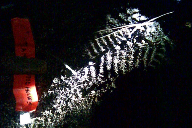
We've all seen the tops of Crocs but has anyone looked at the bottom much? This won't be the last search where Crocs will be involved so take a few moments to look over the attached photo to get to know them. We won't always have the benefit of cell phone coverage and someone at a computer to look it up. Great job everyone! I really missed not being up there! Can't wait to read Allen's report.
June 30, 2008 Horsetooth Resevoir Family Search
Back to Top By Robin A. - SAR Manager21:56 SAR manager page requesting contact with O-3 (Tony S.) regarding a family (Father, mother and daughter.) out hiking in the area north of Duncan Ridge at the east side of Horsetooth reservoir. The family had been out hiking, encountered a rattlesnake, and further hampered by the onset of darkness felt they could not return to their vehicle without assistance. O-3 had cell phone contact with the family that stated they were approximately one-quarter mile north of their car, which was parked in a parking area on the eastern side of the reservoir. O-3 was able to locate the vehicle, make physical contact with the family, and safely return them to their vehicle.
Due to the small area involved only 4 to 6 team members were requested to respond direct to Duncan Ridge for staging. SAR member were stood down at 22:36.
Mission Statistics:LCSAR members: 7. Scott E.,Brian W, Wendy W., Logan H., Stuart G., Leif L., Jose N., and Jake U.
ITC, LCSAR member: 1, (Amy Ho)
Emergency Services personnel: 1
Duration: 40 minutes
Man hours: 4.6
June 26, 2008(Thursday) MM357, Highway 287 Search:
Back to Top0340:On call SAR Mgr call O2 reference a missing 19yoa female near mile marker 357 on Highway 287. Stood down at 03:58 when the female was located. No SAR resources were activated except the duty SAR Mgr.
A page went out at 03:38 this morning to the SAR Manager Group ref. a missing 19YOA female near MM 357 on HWY 287 (just north of Ted's Place. I contacted Ocean-2 and he said the subject first attempted to jump from the car while it was moving at a high rate of speed but the driver stopped her and slowed down. Then when the car slowed down the subject jumped out and took off. O-2 wanted to get a couple dogs and a few ground teams to walk the area in case the subject had passed out and suffering from exposure. She was bare foot and only wearing a small black dress.
Before I was finished gathering information, O-2 received a page saying our subject had been located and so we could stand-down our response. I had him put out a non-priority SAR manager group page saying such and let everyone else sleep. --Dave H.
June 22, 2008(Sunday)Poudre River Dive Assist
Back to Top>18:26 Direct response (non-emergency) page to assist the Dive Team with ferrying stranded hikers from the far side of the Poudre near mile marker 76. Listening to the initial dispatch over the radio, it was obvious there was a sparse turnout from Dive Rescue, so O2 asked 900 to page LCSAR for shore support rope handlers.
O2 was also remembering that there might be a bridge within a mile of that location, so Dave H. went to the resource locater and the web and confirmed that indeed there was a bridge between Poudre Falls and MM76.
At the same time there was a smoke report up the canyon, with O3 responding to that call. And the QRT's were busy sending resources to both incidents. One of the PCQRT engines reached MM76 and located the two hikers. By then one of the hikers had picked his way across the steep slope and crossed the bridge, but his partner was having difficulty negotiating the terrain. One of the firefighters went across and assisted the other hiker in crossing to the road side of the river. Neither of them needed medical treatment. At 19:13 LCSAR and LCDRT response was stood down.
Responders that I know of:
Jose, Sarah, Gilbert, Tom, Tim, Marc, Stuart
plus Jim as ITC and Dave H. for investigation support. --George(L1)
June 15, 2008 (Sunday) Lory State Park Carry Out
Back to Top12:38 Page to respond to Lory State Park to assist PFA for carryout of a bicyclist who was injured. There was a bit of confusion at first because no one was on scene to give any updates or the exact location of the subject. Because of the injury report, Med Evac 1 was dispatched by PFA and was flying around the area trying to spot the spot the subject without having anyone at the patient yet. One Park unit was hiking up Arthur's Rock trail and another Parks unit was transporting PVH paramedics via Parks vehicles up Red Cedar Rd. We were holding people until we determined the best access. The location finally came out when Parks units were on scene and it was determined that the Red Cedar Rd. would be the best access point. Med Evac 1 landed at Arthur's Rock Heli Spot and walked to the subject about 3/4 of a mile down Howard's Trail. Howard's Trail is a new trail in the park and the old maps only show a short section down by the main park road.
PFA-E7 engine experienced transmission trouble and wasn't able to make it up Red Cedar Rd. They transferred equipment into the Parks unit driving up to the scene.
We inserted 2 groups of people with 4WD which included seasonal Fire crew via Red Cedar Rd. The patient was packaged before our units arrived on scene and they assisted with the carryout to the Med Evac 1 ship.
LCSAR Members: 12
Fire Crew: 4
ES personnel: 1
Poudre Fire Authority: 4
Larimer County Parks personnel: 2
Poudre Valley Hospital personnel: 2
June 13, 2008(Friday)Creedmoor Lakes SAR Manager Alert Only
Back to TopSM page received at 2215 to contact ES, O-3 (Tony), regarding two missing individuals in the Creedmoor Lakes area. RP stated two males (21 years and 37 years of age) had left their campsite earlier in the day in a Jeep Cherokee for a locality referred by the RP as Cell Phone Mountain. The last known contact received by the RP was a text message from the men that they had been in a motor vehicle accident while returning to camp and they needed help. O-3 was in route to the RP's location and planned to call the support team to drive the roads of the Creedmoor Lakes area. The SAR team would be called upon later after further information was gathered and the road search was concluded. At 2240, Dispatch paged that the missing men had returned to camp and were OK. No further response by the ES, Support team or SAR was needed.
June 9, 2008(Monday) Estes Park Alzheimer Search
Initial page to SAR manager at 1009 hours on June 9, 2008 for missing Alzheimer's patient in Estes Park. ITC sent team page for trackers, dogs and searchers. 14 members responded, including several trackers and 3 dog handlers.
Subject was 60+ yoa male, who had walked away from a long term care facility. Subject was last seen at 0730 hours that morning. Teams were given detailed information regarding clothing/appearance. Subject's daughter advised that subject was very mobile (able to walk considerable distance) and pretty agile (might climb over fences). Various agencies were on scene at ICP because the search area involved to county and city property. However, the SAR team was at a significant disadvantage due to lack of adequate maps of the area. The primary search area was predominately residential and developed areas, with many new streets that did not appear on older maps (and certainly on the standard 7.5 minute quads).
Shortly after all teams had been fielded, the local paramedics received a call for a disoriented elderly man in downtown Estes Park. It was confirmed this was the subject, and he was in good condition. All teams stood down at 1259 hours.
Thanks to all who responded, and to those additional personnel who were able to respond but held back for the second operational period!
Allen W, SAR manager
Dan F, ITC
June 7, 2008 AM - Berthoud Missing Male
A middle aged male walked away from a nursing home in Berthoud. He was reported missing on 6/7/2008 at 0200 hours.
Searchers and SAR dogs searched throughout the night in an urban area. The person was found in the morning by a bus driver when the man flagged the bus down and asked for a ride to Loveland. He was found 1 1/2 miles from the nursing home.
The man was attempting to go to his home in Loveland.
Agencies:
Larimer County Search and Rescue: 16
Emergency Services: 1
Berthoud Police Department: 1
Totals:
Manpower: 16
Duration: 7 hours
Man hours: 112 hours
Mileage:
350
May 30, 2008(Friday)Minuteman Drive Carry Out
13:08SAR Team assisted Larimer County Parks, Lory State Parks and Poudre Fire Authority in a carry-out of a female who sustained injuries after falling on her Mt. Bike while riding on the Soderberg Trail in Horsetooth Mt. Park. She was cared for by PFA and all assisted in the carry-out to the waters edge where she was transported via Parks Ranger boat to the boat ramp and ambulance.
Original request was for SAR to be a back-up plan if air lift was not needed. 5 members were inserted into the field to assist in carry-out and 7 were on stand-by at the trail head in case more were needed.
Larimer County SAR members: 12
Page out: 13:08
Stand down those not on scene: 14:13
Debrief and release: 15:45
Duration: 3.75 hours
Man hours: 33
May 26, 2008(Monday)Soul Shine Rd(FR122) Search
By Robin A. - SAR Manager
Monday May 26, 2008, 1303 initial page requesting SAR manager (Mark) contact O-5 reference a missing 23 year old male, described as large build with long brown hair, blue jump suit and wearing a red and white Santa hat in the area of Soul Shine road. Male was last seen by his camping friends at approximately 2230 on the 26th at their campsite (UTM 668-716). The morning of the 27th the RP's discovered subject had not returned to the campsite. They searched the area locating subject's backpack and cell phone approximately 150 yards uphill from camp. After rummaging through the backpack, it was decided they should call SAR.
During interviews, the reporting parties gave conflicting information as to the mental status and/or physical abilities of the subject. Further inquiry by a Larimer Sheriff investigator was needed to retrieve information from the RP's as to subject's attitude and activities prior to his disappearance. Additionally Loveland PD preformed a courtesy check of subject's residence and found it pad locked. An inquiry at subject's place of employment declared he was not expected to return to work until Wednesday May 28th. Later an Estes Park dispatcher relayed information of a person fitting the description of subject had been seen walking along Hwy 34 approximately 0330 the morning of the 27th and then again, believed to be the same individual, reported seen near the Dam Store around 0700.
Six SAR teams were deployed searching multiple 2-mile sections along hwy 34 and the Thompson River covering a distance of Six miles down river from the campsite. Additionally a tracking team and a dog team, deployed from the campsite. A third team was assigned to search the area known as Sugarloaf near the campsite. To the west another team searched the area of Forest Service road 122 and the residential area of Pole Hill and two members of the Support Team searched roads with ATVs. At 1827 the team searching FR 122 contacted a civilian ATV group that reported having seen a male fitting the description of the subject, dressed in blue, walking on the road but could not remember the location. Later, the team was able to contact the individual walking on the road and establish that it was not the subject.
The civilian ATV riders had also commented they seen a Red Santa hat back on a loop road, and they took the two LCSAR members on their ATV's to search the area for the Santa hat but failed to locate it. At 2020 Larimer dispatcher contacted O-5 with information that an informed friend had made phone contact with subject who was at his residence and in good condition. All teams were recalled to base and dismissed from the area approximately 2150.
Weather for the area was rainy with some thunder and lightning just before dark and temperature of 42 degrees with moderate winds from the east.
Mission Statistics:
LCSAR members: 28 (including 4 trackers, 2 dogs)
ITC:1 (LCSAR member, Jim Mines)
Emergency Services personnel:1
Support team members: 2 (Tony Simons and Robert Le Gaspi)
Total miles driven: 1936 (22 personal vehicles round trip 88 miles)
Total hours: 266 (9.5 hours from start to finish)
February 9th, 2008(Saturday)Summit County Search Assist
Back to Top17:00: Received a page to call the CSRB coordinator ref. a request for trackers to assist Summit County in a search for a missing 23 year-old male who was last seen leaving a bar in Breckenridge on the morning of Friday the 8th. It was believed that he was intoxicated and the weather produced snow and blowing snow with winds in excess of 65 MPH. They later requested any kind of searchers from LCSAR as well.
5 team members and one air-scent dog went to assist and were to meet at the Breckenridge Recreation Center at 0800 on Sunday the 10th. We split up into two different teams, one being the dog team to cover some high probability areas and another foot team/tracking team to cover a couple search segments close to the point last seen. Neither team came up with any clues that would warrant more searching in their segments. The snow was deep and difficult to travel in without the use of snowshoes. All team members were debriefed around 1700 and returned to Ft. Collins.
Note: The search was suspended and continued later in the spring when a credit card of the subject was located. Search teams search the area and located the body of the subject in a small group of trees South of the PLS in an open field area.
Dave Hake
January 12, 2008(Saturday)Bobcat Ridge Natural Area Search
Back to Top16:32 SAR Manager page for L-1 to call S-17 (Kevin J.)regarding a lost hiker at Bobcat Ridge Natural Area (which is southwest of Masonville). George J. L-1, Robin A., who is in training to be a SAR Manager, and Kevin had a three-way phone conversation to get the details and decide on a response plan. A 40's year old female was hiking the Ginny Trail, and atop that western ridge she noted the trail wasn't going in a direction that she felt comfortable with at that hour, with sunset imminent. She was able to see the main trail in the lower elevation to the east, and decided to cut cross country to reach it. Well, as those of you who've hiked the area know, there are a series of drainages coming off that ridge, and when she got into one, she lost her reference points and decided to call 911, which enabled Dispatch to obtain her GPS coordinates 40.473514, -105.242779) (UTM 13T 0470420 4480343). Two City Parks Rangers were still on duty there, and had also been notified. While Kevin was en-route, one of them drove their Gator-type ATV up the access road and was able to locate and access her location. She was wearing dark blue clothing, but did have the presence of mind to put her light blue fleece atop her jacket, which aided the Ranger in visually locating her. Kevin did continue on to meet with them, and the Team's participation was stood down at 17:01.
January 12, 2008(Saturday)Cameron Pass Area Search
Back to TopAt 20:02, L-1 George J. received a non-priority page with just a phone number, which turned out to be from Kevin J. Dispatch had notified him of a call from a concerned mother about a trio of teenage males (2 of 16 yoa, 1 of 18 yoa) who had not yet returned from snow boarding somewhere in the Cameron Pass area. After talking with the respective mothers, Kevin determined the trio had departed Fort Collins at 12:30, and that there was no consensus as to when the teens were expected home. One of the mom's did provide a vehicle description, but she didn't know the license plate number. Kevin explained to them that the drive time and time for one run before darkness settled in would make it unlikely they could return to Fort Collins before 20:30. Kevin and George were still on the phone discussing avalanche danger and response options when Kevin was paged at 20:16 that the teens were home.
Diamond Peaks Ski Patrol normally patrols some portion of the Cameron Pass area each weekend, and when they do so, the leader of the day calls Dispatch to advise how many patrollers and where they will be. Kevin did check with Dispatch about any DPSP patrollers that might have been in the area, however dispatch did not have any record of them calling in. Part of our nascent plan was to have Dispatch page the DPSP group to ask if any had been up around Cameron Pass. In addition, with the avalanche danger rating of 'Considerable' (plus known prior avalanche activity in the area from the CAIC daily reports) and it being dark already, we were planning a minimal initial response for attraction purposes, with a full response for early morning. [Incidentally, on Sunday morning while I was driving to the Tracking training, I heard DPSP call in to Dispatch that three patrollers would be in the Agnes Lake area for the day.]
George