Larimer County Search and Rescue
Mission Reports 2007
December 11, 2007 TIMBER RIDGE TRAILER PARK SEARCH
December 2, 2007 - CAMERON PASS AVALANCHE RESCUE
November 19, 2007 Arthur's Rock Carryout
November 11, 2007 RMNP Lawn Lake Missing Hiker
October 25, 2007 Loveland PD Assist Missing Juvenile
October 22, 2007 Pingree Hill Lost Hunter
October 11, 2007 Wellington Juvenile Search
October 2, 2007(Saturday)Horsetooth Mountain Park Carryout
September 26, 2007 RMNP Mummy Mountain Search
September 20, 2007(Thursday) Red Feather Suicide Search & Recovery
September 16 & 17, 2007 Sand Creeek Hunter Search
September 11, 2007 Rawah West Branch Bow Hunter Carryout
September 9, 2007 South Lory State Park Carryout
September 5, 2007 Big South Jones Search
September 2, 2007(Sunday)Horsetooth Falls Carryout
August 20, 2007 RMNP Keyhole Carryout Assist
January 2, 2007 Montgomery Pass Search

December 11, 2007 - TIMBER RIDGE TRAILER PARK SEARCH
Back to TopBy: Mark Sheets – Relief Duty SAR Manager
08:37 Page goes out for SAR to respond to Timber Ridge Trailer Park near Taft Hill and CR-38E re: a missing 9 YOA male.
Sheriff Deputies had been looking for the youngster for about 30-minutes but the lad had been missing for about an hour prior to their arrival. The young man bolted out of the window of his residence after being advised by his mother that “He WILL be going to school today”. The young man had a history of leaving when he was unhappy and his mother said he has no concept of hot or cold as he is somewhat mentally challenged. It was about 25 degrees with about 6” of fresh snow on the ground with more snow falling. He was dressed in tennis shoes, jeans and a Dallas Cowboys jacket.
Dogs, trackers and searchers from LCSAR responded to join the search in progress with Larimer County Sheriff’s Dept. Dispatch sent a reverse 911 to the area which began to elicit reports from a number of residence stating they had seen him in the area West of his residence. This focused the search area and eventually, a deputy spotted the lad trying to elude the searchers. He pursued the boy on foot and eventually caught him. He stated he saw the patrol car in front of his residence and decided to try his best to elude them. He was returned to his residence and all units were stood down at 09:59.
MISSION STATISTICS
4 Larimer Sheriff Deputies
1 Emergency Services Specialist
19 LCSAR members, with 2 dogs
150 total miles (15 personal vehicles at nominal 10 miles avg. round trip)
33.25 man hours (1.75 hours from start to finish)
...continued
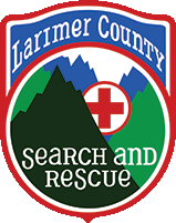
There were tracks in the snow leading away from the subjects bedroom window. They had about 2 inches of snow on top of them. We started dusting and brushing them and Scott did a great job in finding the signature track after brushing away the snow on one print by the window (see attached) It had some transfer from when the subject jumped out of the window and hit hard all the way down to dirt. It transferred to the next step where it showed up in the snow.
The subject was located between two mobile homes by one of the deputies. We went to the location where the subject was found and found the signature print in that area (see attached)
This was just the snow tracking side that others might be interested in. We had it heading south and were in the process of determining if he went East or West at the first intersection but had a hard time due to all the tire traffic on top of it. After the find, we back tracked him and he came in from the west and heard from neighbors that said they saw him walking west about the time he went missing. We think he was hanging out around the mobile homes and on his way back.

"Never let them tell you there aren't tracks to be found!!"
December 2, 2007 - CAMERON PASS AVALANCHE RESCUE
Back to Top(Incident # 073360023) By: Mark Sheets – Duty SAR Manager
12/02/07 13:46 Page: “PCQRT, SAR, SKI AND ES- PLEASE RESPOND TO THE MONTGOMERY PASS PARKING LOT APPROX MM65 FOR A SKIER THAT WAS IN AN AVALANCHE. HE IS OUT – BREATHING BUT NOT RESPONSIVE. UNK HOW FAR UP HE IS, RP IN PARKING LOT. SARA/COMM”
Shortly thereafter, it was determined that staging was actually to be at the Zimmerman Lake TH as the avalanche was in the HOT DOG BOWL, not Montgomery Pass. The subject, in a party of three snow boarders who were on foot had reportedly been buried in approx. 10 feet of snow for 10-15 minutes after the entire bowl slid. Two in the party managed to get clear when they noticed the slide starting. The subject was located by his buddies fairly quickly using an avalanche beacon (the all three had them). The two dug him out of the snow and started CPR. Eventually they noted the subject was breathing but not conscious. They transported the subject (means unknown) some distance towards the trail head in anticipation to meet rescuers coming in on the trail.
Lee Lang and a Colorado State Parks Ranger were some of the first responders on the scene and headed up immediately at 15:30hrs. The majority of SAR and Ski Patrol arrived at the trailhead and starting in by 15:50. A Ski Patrol toboggan from the Zimmerman Cache and other supplies were used on the rescue.
Rescuers reached the subject around 16:05 where they packaged him and headed down the trail, arriving at the trail head at 16:32. The subject was loaded into a waiting Jackson County (Park Hospital District) Ambulance where he was stabilized as best as possible prior to being transported to Joe Wright Reservoir Parking to be loaded into an awaiting Air-Life helicopter. From there, the subject was flown to Medical Center of the Rockies in Loveland. Status of the subject is unknown at the time of this writing.
I would like to thank everyone involved on this rescue. It was a great, cooperative effort by Poudre Canyon QRT’s, Larimer County SAR, Diamond Peaks Ski Patrol, Larimer County Sheriff, Jackson County Sheriff, Lake Hospital EMS, Colorado State Parks, Greeley Air-Life and his friends that were with him when this tragedy happened. From Page out at 13:46 to “In Ambulance” at 16:32 (2.75 hrs) is excellent considering it is a healthy 1.5 hour drive from Fort Collins to the trail head. WELL DONE!!
All resources were back in town by 19:30 hours.
MISSION STATISTICS
1 Emergency Services Specialist
17 LCSAR members
2 LCSAR SAR dogs
9 Diamond Peaks Ski Patrollers
2 State Parks Rangers
1 Helicopter
2730 total miles (21 personal vehicles at nominal 130 miles round trip)
149.5 total man hours (5.75 hours from start to finish)
NOTE: This slide happened around 12:30 on a SE facing, wind loaded slope and was most likely triggered by human(s).
November 19, 2007 Arthur's Rock Carryout
Back to Top1425 hours: LCSAR team paged to respond to Lory State Park for fallen horse rider.
Subject was in the meadow South of Arthur's Rock parking area, near the horse jumps. PFA and park personnel was initially called and on-scene before any LCSAR personnel arrived. They had enough personnel to load the subject into Airlife for evacuation.
1449 hours: LCSAR team stood down. No LCSAR team members were fielded. 9 SAR members and truck 10 were enroute at time of stand-down. Medical condition of subject in unknown.
Allen, SAR manager
November 11, 2007 RMNP Lawn Lake Missing Hiker
Back to Top0722 hours - Page for SARDOC dispatcher to contact RMNP re missing subject.
RMNP initially requested one air scent dog on standby for missing subject; no other resources from LCSAR were requested. Subject missing over 2 days, and vehicle located this morning. Hasty team from the park started up the Lawn Lake trail, and smelled smoke. Park team located campsite where subject left a journal, and the campfire was still warm. After reading journal, the park suspected the subject might be suicidal. One trailing dog was going to be fielded from the campsite, with park ranger as support. Before dog team was fielded, rangers located the subject wandering down the Fall River Road. Subject was apparently cut and lucid, but other medical condition is unknown.
Dog teams stood down at 1010 hours 11/15/2007, Allen
October 25, 2007 Loveland PD Assist Missing Juvenile
Back to TopDog Request Loveland PD
We had a request at 10:10 for dogs from Loveland PD to help find an 11 yoa male who took off at 07:00 to avoid going to school. I was covering for Mike F so I took the call. When I reached Loveland dispatch they were already on the phone with O2. I was filled in by O2 and began looking for dogs. They only wanted one or two. I first reached Mike E and got him and Merlin en route. I felt that Bear and I were a good resource as a trailing dog made sense. I took a few minutes to get ITC coverage and then headed to Loveland.
When I arrived on scene Mike had scent articles and had just finished clearing the residence. I started Bear and worked to the north for about 20 minutes when we heard over the radio that subject had been located walking along a road. The stand down came at 12:15. Dan
October 22, 2007 Pingree Hill Lost Hunter
Back to TopSAR Manager Alert Only
SM page about 10:45 AM regarding a lost hunter in the Pingree Hill area. He had not made a planned rendevous, and had been last seen about 2.5 hours before. ES was having a hard time getting back in contact with the reporting party. Forest 15 was in the area trying to contact the RP and Sam 7 was on his way up to the area from town. We were going to start seeing what LCSAR resources were available when S7 got the page that the hunter had been located.
For those of you not familiar with it, note that Pingree Hill is not in the Pingree Park area! Pingree Hill is the hill between Rustic and the Manhattan Road, just east of Goodell Corner (another good landmark to know) and west of the Ben Delatour Scout Camp.
Road conditions are bad in the hills----it rained before it snowed up there, and there have already been many accidents.
Are your fuzzy mittens in your car? Sarah
October 11, 2007 Wellington Juvenile Search
Back to TopBy: Mark Sheets – Duty SAR Manager
16:45 Page: SAR Manger requested to call Dave Mosier. 17:09 Page: SAR respond direct to Wellington Jr High School reference missing 10 yo male.
The subject was last seen around 15:15 hours, running away from an after school day camp after being admonished for doing something not permitted by rules. The subject stated that he is going to “run away to be with his dad who lives in Nebraska.” Larimer Sheriff was notified of the runaway and deputies started to search the area for the subject.
SAR arrived at the ICP at Wellington Jr High School and immediately deployed trackers, dog teams, foot searchers and mobilized units. A dog team that was assigned to the West side of town (the direction the subject ran) had just began their assignment when they noticed a youngster walking North on the Rail Road on his way “out of town”. The subject was some distance ahead of them and while attempting to catch up to them, a black SUV was spotted approaching the subject. The subject willingly got into the vehicle. The dog team intercepted the vehicle to find it was driven by the local Soccer Coach who had heard of the search and decided to help. The subject was driven back to the ICP and reunited with his parents by 19:00.
MISSION STATISTICS
3 Larimer Sheriff Deputies
1 Emergency Services Specialist
2 School Security Guards
17 LCSAR members
2 LCSAR SAR dogs
629 total miles (17 personal vehicles at nominal 37 miles round trip)
42.5 total man hours (2.5 hours from start to finish)
October 2, 2007(Saturday)Horsetooth Mountain Park Carryout
Back to TopDirect response page at 13:37 for hiker at Horsetooth Mountain Park (HTMP) that had an injured ankle. The page from dispatch did not specify the type of response, so Code 3 (emergency lights and siren) is presumed. Moments later we received the page to downgrade response to non-emergency, per Ocean 3, Tony S. You can expect that for minor injuries and no threatening weather that any direct response will be downgraded to non-emergency -- it's simply a risk-benefit concern. PFA and PVH were responding, and asked for our assistance since the preliminary location had him 1.5 miles up the Horsetooth Mountain trail, and they weren't sure if they could drive close enough. Our subject was a 60's year old male who was hiking with his family and somehow turned his ankle out of alignment with his leg (Tony did not get specifics about the mechanism of injury). The Team staged at the parking lot, which was as far as we got.
With Allen out of town for the day, I was covering as L-1. Since I was on the north side of town, I started toward the Cache in case no one else was going for Truck 10. Mark S was also heading that way but from the south end of town, so I told him to go direct to HTMP. No one else was at the Cache, so I threw minimal gear in Truck 10 and responded to HTMP. Tony S had gotten into the traffic mess of people going to Hughes Stadium for the CSU game, and asked dispatch for a better route. They aired and paged out routing information from FCPD (they have specific routes planned for game days to facilitate traffic flow to the stadium, see http://fcgov.com/news/index.php?id=2145&home), which presumed that we'd be responding via Centennial Drive (over the east side dams). I went south on Shields, cutting across the access routes, so I had no more traffic than usual for a Saturday.
We had a rather light response for the mission -- on scene (at the parking lot) were myself, Mark S (as L-2), Jeff G, Paul M and Gilbert Y, with Sarah B, Bill D and Mike E enroute, but the stand down page went out at 14:16, before they arrived. If anyone else was responding, please let me know via e-mail.
Thanks for the response. George
September 26, 2007 RMNP Mummy Mountain Search
Back to Top0952 RMNP paged us to see if we could send some dog teams to assist them in a search for an overdue hiker who was to summit Mummy Mountain East of Lawn Lake and was due out the night before. L-1 was Out of service so again, I took the call as L-2.
The subject had been emailing co-workers with a cell phone with his progress up to the 12,500ft mark on the SE ridge heading to the top. His phone wasn't working the best and he wasn't heard from after that. The park was still in hasty mode and covering all the likely trails and wanted to get a small head start by incorporating Dogs into the search early.
We had 2 dog teams with handlers and support people responded. Zmijewski, Followill, Purvis, Udel responded. Zmijewski and Followill were inserted via helicopter to the saddle NW of the summit and the second team was still waiting on a helicopter ride in at late morning and since the handler needed to be at work later in the day, they chose not to insert.
Team was paged for more searchers and Trackers for stand-by on yesterday and then for searching for today.
1835 the subject was located by RMRG folks hiking in the Lawn Lake trail on their way to an assignment. I'm not sure what the subject did in the mean time. The dog team was finally out of the field by 12:30 this morning. Short ride in with a Long hike out!
Resources used from our team:
1 SAR Manager arranging teams
1 In Town Coordinator arranging teams
4 LCSAR members
48 total man hours
65 total miles driven
September 20, 2007(Thursday) Red Feather Suicide Search & Recovery
Back to Top(Janson) Red Feather Lakes – despondent 75 year old male
Perhaps, as he walked alone on this bright autumn day, the calls and antics of the Steller’s Jays made him smile, as they so often did while at his bird feeders. Everyone else was gone from the house, set amidst the pines near the mountain community of Red Feather Lakes. He had a goal and a mission to accomplish. He carried an essential tool, and though it was a bit heavy for his aging body, he was in no hurry to reach his goal, and so paused to rest often, taking in the sights and sounds for one last time. Indeed, at a large Ponderosa Pine tree that is about 50 feet from his goal, the trackers found evidence that he had paused there, leaning both the tool and himself against the trunk, perhaps to gather strength from the mighty tree for the final climb to his goal, a cherished space amongst the hill of rocks before him. Perhaps it was nearing sunset – the view from his cherished space expands from east to south to west – one last sunset before the blessed peace that would soon be his – no more torments from the myriad ailments that had wracked his body for the last decade. Searchers found his lifeless body the next morning, and after the obligatory coroner’s investigation of the unattended death, they gently removed him from that cherished space, consigning the body to the grieving family.
The call from the family that he was missing had come to the Sheriff’s Office the night of Wednesday 19 September 2007. It was assigned to the mountain deputy, Edward-23, whose investigation revealed that the missing person was potentially suicidal, and that certain personality traits might cause him to pose a danger to the volunteer searchers. The Emergency Services personnel were notified, and concurred with the decision to delay fielding the SAR team until the next morning. The family had been searching throughout the evening, and would continue to do so.
At 08:50 Thursday 20 September 2007 the duty SAR Manager was paged to call Tony Simons, Ocean-3, regarding a search for a despondent 75 year old male who was last seen at about 14:00 on Wednesday. Thirteen members responded, including two dogs. The deceased subject was located by one of the search teams at about 12:34, and the mountain deputy, Edward-19 this time, was on scene at about 12:37. The coroner’s investigation was completed by about 15:00, and all resources were back in town by about 17:00.
1 Sheriff’s Office mountain deputy
1 Emergency Services Specialist
13 LCSAR members
2 LCSAR SAR dogs
630 total miles (7 personal vehicles at nominal 90 miles round trip)
104 total man hours (8 hours from start to finish)
September 16 & 17, 2007 Sand Creeek Hunter Search
Back to TopInitial page: to SAR manager at 2229 hours on Sept 16, 2007
Scenario: lost hunter in area of Sand Creek (West of Red Feather Lakes) Subject info: Male, from Greeley, bow hunter wearing camouflage. Numerous medical conditions: RP: son-in-law, who had been in the field with the subject hunting. Equipment: did not take his survival pack with him. Carrying 9mm handgun, elk bugles, flashlight, unknown what boots he was wearing. Background and LSP: Had been camping and hunting in the area since Friday. Previously hunted this area for many years. RP stated that they left the end of the road, and went about 300 yards into the woods, where the subject was going to "circle back" to a meadow. However, then RP tried to show teams where the LSP was, he became disoriented and the RP and teams ended up back at ICP. So LSP was not well defined, and could not be located in the dark. However the RP said the subject would not travel very far, due to his condition. Weather: Temp in the 40-50's with rain, light winds, hail just prior to search, and much darkness. Team response: 12 team members responded including a dog team and several trackers. ES also had two ATV's respond from the cache. Several members responded directly from Wyoming. This involved a rather long rough drive in from Deadman Road, on predominantly 4WD roads. The team responded from the cache about 2345 hours. Outcome: Subject located by Team 1 (dog team) shortly after 0400 hours on Sept 17, code 4---other than bumps, bruises, twisted knee, and sore hip. Subject was approximately a mile from ICP. Team 1 was able to walk subject to a road, where he was picked up by ES and family members. A radio relay team was very instrumental in this mission, and was the last team to leave the field. Most members returned to Fort Collins or Wyoming by 0830 hours. ICP was at UTM 366/221. Subject located at approximately UTM 378/229. Thanks again for the good response! Allen W. SAR manager
September 11, 2007 Rawah West Branch Bow Hunter Carryout
Back to Top 9-11-2007 1515 Team paged to respond emergency for a carry out of a bow hunter in the Rawahs up West Branch Trail who had severely lacerated his leg. While units were in route, Greeley Air-Life was able to land close to the subject, package and transport to Medical Center of the Rockies. Once Flight Medics were on scene with the patient, SAR was stood down. All SAR units were back in town by 1645. 1 Medical Helicopter 4 Larimer County Fire Crew members 1 Larimer County Sheriff - Emergency Services Specialist 14 Larimer County SAR members 672 total miles, 12 personal vehicles 56 miles round trip (estimated) 21 total volunteer man-hours SAR Manager: Mark Sheets
September 9, 2007 South Lory State Park Carryout
Back to Top1510 Team paged to respond non-emergency for a carry out of an injured 8yo female who was thrown from a horse in Southern Lory State Park. SAR was asked to stage at Towers Road off Minuteman Drive in Northern Horsetooth Mtn Park as the subject could be accessed by vehicle except for the last 100 yards. Poudre Fire Authority and PVH Ambulance responded to the South end of Lory State Park and decided they could handle the carry out with their personnel and Lory State Park Rangers that were on scene. SAR was not fielded. All teams back in town at 16:10
3 Larimer County Parks Rangers
Unknown number of responders from Lory State Park
1 Larimer County Sheriff - Emergency Services Specialist
16 Larimer County SAR members
448 total miles, 16 personal vehicles 28 miles round trip
16 total man hours
SAR Manager: Mark Sheets
September 5, 2007 Big South Jones Search
Back to TopSummary: Second Ops period, Terry and Marion Jones search
Ops: Mark S. IC Kevin J.
Ops location: Long Draw Rd / Peterson Lake Rd intersection.
Team 1
[Dave H, Doug G]
Inserted at the end of Crown Point Road at the Zimmerman Trail, searched and cut for sign South on Zimmerman Trail to the Flowers Trail. Went West on Flowers Tr. To intersection of Mirror Lake Trail then back to the East on Flowers to the Cabin Trail intersection in Section 8. Returned to vehicle at the insertion point via Zimmerman Trail. Was unable to debrief Team 1 in person due to geographical separation.
Team 2
[Alan W, Robin B – Rosie, Air Scent Dog with scent article] Inserted at Peterson Lake, walked SE to the Big South Trail, then South on Big South Trail (West side of creek). Rosie showed some interest at Camp #17 at UTM 358/882 but was insufficient to follow up. Proceeded South on Big South to Corral Creek Trail. Recovered by L-1 in vehicle and transported to the Gate of Cow Camp on Long Draw Road. Walked from there back to ICP on Long Draw road with winds coming from down the road - No interest. POD = 50% 100 yards either side of the their trail. Team 2 debriefed by OPS.
Team 3
[Robin A, Larry S, Toss Air Scent Dog with scent article] Inserted at Peterson Lake, walked SE to the Big South Trail, then South on Big South Trail (West side of creek). Toss had mild interest at Camp #17. Proceeded South on Big South to Poudre River Trail then up Hague Creek to Hague Creek Campground. Searched the South side of the campground extensively. Proceeded up-valley to Resolution and Flatiron campsites. No interest in the valley at all. Started up Mummy Pass Trail a way then got recalled. Walked out to Corral Creek and met OPS at the Ranger’s Cabin. Team 3 debriefed by OPS.
Team 4
[Darryl T, Paul B, (RP that sighted subjects on Sunday, 9/2)]
Started at Peterson Lake and proceed to PLS at UTM 340/896. Searched while cutting for sign South on Big South Trail. Intercepted 4 friends of the Jones’ that were searching on their own. Searched the East-Facing slope up to high point 10742 in section 36 (UTM 351/867) Headed down hill, straight south to intersect the Corral Creek Trial. Ended at Corral Creek Ranger Station. Team 4 was debriefed by OPS.
Team 5
[Denise A, Chad K] Inserted at Peterson Lake, crossed Big South at Flowers Trail then East on Flowers to Mirror Lake Trail. Continued South, up Mirror Lake Trail until recalled. Did not complete Mirror Lake Trail due to recall. Recovered to Peterson Lake via same route in.
Team 6
[Josh C, Dave F] Inserted at Peterson Lake, headed up Bid South then up the drainage the leads South through the middle of section 36. Then West to the high points near UTM 348/872. Heavy trees with lots of downfall. Topped out at high point 10742 then over to high point 10900 then North to UTM 340/872. Descended the re-entrant drainage that leads back to middle of section 36, then back to Peterson Lake on the Big South trail. Est POD = 20% of route covered. Team 5 was debriefed by OPS.
RMNP Team 1
[Unknown members – qty 6] Walked the subjects intended route, starting at the Chapin Pass Trail Head and walked down-stream along Cache La Poudre to Big South, Continued down Big South, covering both sides from that point on. Recovered by OPS at Peterson Lake. POD = 70% within 100 feet of trail walked. RMNP Team was debriefed by OPS.
Comments:
Triangular area bound by Hwy-14, Big South and North of Barnes Meadow Reservoir including high points 9401, 9634, 9435, 9986 and 9750 should be high priority for next Ops period. Suggest that the high points South of Barnes Meadow and North of today’s ICP be considered as second priority. Third priority should be the Zimmerman Trail, North from the Crown Point parking area.
September 4, 2007 // Summary: First Ops period, Terry and Marion Jones search
Ops: Sarah B. Also present for first half of day: Justin W, Kevin J from S.O.
Ops location: Big South trailhead (highway 14), then moved to Joe Wright Reservoir parking lot (highway 14) in attempt to get better radio coverage.
Area had received significant rain in the last 24-48 hours.
Team 1
[Scott E, Mike E, Merlin (air scent dog)] No scent article, so Merlin just working in ‘find anyone out there’ mode. Inserted at Corral Creek trailhead off of Long Draw Road. Proceeded east on Corral Creek trail to intersection w/Big South-Poudre River trail. South on Poudre River trail to Mummy Pass trail. East to trail spur which goes to camp sites (Desolation Peak, Deadman, Flatiron). Merlin showed much ground interest at Deadman camp site, indicating that someone had camped there recently. Met with RMNP ranger 421(?) Jim. Proceeded back to Poudre River/Big South trail and headed North toward Peterson Lake. Checked campsites #16 – 20 along Big South trail. Met teams 2 and 3 at Peterson Lake and exited field. No significant clues. Cutting for sign and using loud attraction the whole time. Poudre river is easily crossed if necessary.
Team 2
[Doug G, Jeff G] Inserted at Peterson Lake, off of Long Draw Road. Cut for sign in vicinity of Peterson Lake (several trails around it and between it and river). Proceeded to river. Met two backpackers who had been on Big South trail since Saturday (with two dogs) and not seen anyone. They had begun and were ending at Peterson Lake. Cutting for sign, using loud attraction, and headed north along unofficial trail on west side of Poudre (hikers from south often don’t know they have to cross to east side at some point to pick up the Big South trail, and continue on west side of river, eventually getting ‘cliffed-out’ farther north.) Continued north along west side of Poudre. One possible clue found at UTM 320 920: partial, fresh wrapper from snack bar of some sort. Wrapper has red, green, cream colors, with green circle in corner containing the words “Smart Choices Made Easy” within it. Occasional, indistinct sign, otherwise. At UTM 320 925 could not continue any farther north due to cliffs, and turned around. Returned to Peterson Lake and exited field.
Team 3
[Lee L, Jose N] Inserted at Big South trailhead. Proceeded south on trail, checking campsites #1-16, cutting for sign, using loud attraction. Cleared Big South trail to intersection with Flowers Trail. Found sign (indistinct) at junction of Big South and Flowers trail. Cleared a short way up Flowers Trail. Crossed Poudre River and met teams 1 and 2 at Peterson Lake, exiting field.
General Comments:
All the above trails were easy to follow, not dangerous. Air scent dog not an efficient tool in the dense timber with no breeze and no scent article. River could be easily crossed in many locations. All of the above trails can be considered cleared for now and not in need of additional resources in 2nd Ops.
September 2, 2007(Sunday)Horsetooth Falls Carryout
Back to TopSunday Sept 2nd 16:00 SAR team paged for possible carryout of a 13 YOA child who fell from the top of Horsetooth falls into a spot where they couldn't go up or down. We were going to be on standby at the Trail head and wait to see if Poudre Fire Authority who was already in route needed any help. Subject was evacuated by PFA from the Falls and subject walked out. Sar Team was stood down 16:22
10 SAR members were in route or at the staging area. - -Dave Hake
August 20, 2007 RMNP Keyhole Carryout Assist
Back to Top09:00, Rocky Mountain National Park (RMNP) called to see if we could assist them in a carryout of a 48 YOA female who fell yesterday afternoon just past the Keyhole on the Long's Peak Trail. 10 LCSAR members responded with one of them being a Physician to assist with the medical on the subject. Subject was raised 200 ft. to the False Keyhole then lowered 500 ft. to the Boulder field where she was carried to the Landing Zone for Fight for Life to transport her to Upper Beaver meadows. Our team members were almost to the landing zone to assist in a long carry out if the helicopter was unable to transport. A couple team members made it to assist in the carry to the LZ and assist with medical. All Team members were back in Town at 20:00.
August 14, 2007 Edward 19 Rollover Search Assist
Back to Top8-14-07 08:08 Sar Manager group received page to send a couple trackers to assist Mountain Deputy in a possible search for subject who reportedly ran from a roll over crash sight. Supposedly there were a total of 3 in the vehicle. The other 2 were taken to the hospital. The only requested 2 trackers at this time to limit exposure in an unknown situation as to whether or not the subject was armed. The car was towed, and no scent article for dogs and again to limit exposure they decided not to call dogs in at that time. We requested one more tracker and it was approved. We cut for sign with Mountain Deputy covering us and found fireman tracks going up the hill and a few that we couldn't determine if they were fireman or the subject.
As we were working it, we received call from dispatch saying the two subjects in the hospital admitted there wasn't a third and that they were trying to get out of a DUI charge. Search was called off around 11:00
No "all team" page was ever put out due to the limited request. - -Dave Hake
![]()
July 30, 2007 Eaton Resevoir Dirt Bike Search
Back to Top00:15 hrs. Report of a female overdue from a Dirt Bike ride in the area West of Eaton Reservoir. SAR personnel responded to the area and started searching the many Forest Service roads and the logging spur roads. The 22 yo female went for a short ride after dinner. She was with her boyfriend and his mother on a visit to the boyfriend's parents cabin located on CR-80C. Her boyfriend said that she was going to ride for about 30 minutes that started at 18:30 but worried that if she stalled the motorcycle or crashed, she would most likely not be able to re-start the motorcycle as the kick starter is very hard to crank. He started to the motorcycle for her before the ride. Her intentions were to ride Forest Service road 336 (Sand Creek Pass Road) and be back to the cabin before dark since dirt bikes do not have headlights.
SAR searched all night and found many Solo motorcycle tracks on 336, Deadman Road as well as many other forest service roads. She had driven all over in a large area. The mother and the son had been out all night, running roads looking for the girl and had covered many roads before we arrived to search.
After taking inventory of what roads had been searched, it was decided that FS-212 had not had anyone on it. One team that was in an area that had no sign of motorcycle tracks were reassigned to Road 212 and eventually encountered the missing subject. She had wrecked on the motorcycle and was unable to restart it. She abandoned the motorcycle and attempted to walk out to a main road before dark but nightfall happened. She decided to build a fire (she had cigarettes and a lighter with her) in the middle of an intersection and wait out the night. The subject was located around 07:15 on 30-JUL-07. The locating team had a pickup and was able to go to where she left the motorcycle, load it in the pickup and drive back to the ICP. A different team had located her fire, still in embers and extinguished the remains thoroughly.
All units were back in Ft Collins by 10:30. - -Mark A. Sheets
Mission Statistics
Vehicles: 7-FWD, 2 ATV’s
Total miles: 770miles (figured from the cache)
Personnel: 14-SAR, 1-ES, 1 – Resource Team Member
Total Hours: 160
July 23, 2007(Monday)Lost Hikers Hewlett Gulch
Back to Top3:49 PM SAR manager page: SAR manager on call, pls. call Tony Simons ref. a couple of lost hikers he's working on.
Two hikers, a 34 yoa male (Noel) and a 29 yoa female (Ashley) had called 911----they thought they were in the Hewlett Gulch area, but were lost. Before their cell connection was lost they were able to tell dispatch that they'd seen a sign which to go straight for the loop trail. Also that they had a black Subaru Forester, the woman was wearing a white tank top, and that they were out of water. Because of the Phase 2-type cell phone it didn't automatically give their geographic coordinates, and dispatch forgot to 'ping' their phone, so we knew their call had gone through the tower near the Graves Dairy (on the flats not far below Ted's Place) but we didn't know where they'd called from. Dispatch was working on getting Verizon to give us the location of their phone, and repeated calls back to the subjects couldn't get through.
Since we didn't know where their vehicle was Tony just wanted to get a small group of us prepared so we could respond if/when their vehicle was found (so we'd have a place to start). So I sent out the first page ref. needing searchers, trackers and a trailing dog for the *possible* search in Hewlett Gulch area, and that we wouldn't know for sure if it's a go until the vehicle is found.
The only loop trail Tony and I knew of in the Hewlett Gulch area was the loop created by the two Grey Rock trails, so we thought they might have tried to do that loop but gotten off the trail somewhere and maybe ended up in Hewlett as so many of our Grey Rock subjects have. Tony started up the canyon to see if their vehicle was at Grey Rock or Hewlett Gulch, and shortly after that asked us to follow, to at least get us going up in that direction. So I sent out a second page asking for the 10 folks who Eric (the In Town Coordinator) had spoken with, to proceed to the cache. Dispatch then was able to get the lat/long coordinates of their call, Tony plotted them back at the cache, he and Dave H. got a good aerial photo and map of the area, and it showed them on the large loop trail off of the main Hewlett Gulch trail. Most of us hadn't realized there was any trail off of there!
By this time we had more than enough folks at the cache, for what appeared like it would be a simple walk up the trail to say hi to these folks, give 'em some water and food, and walk 'em out. My apologies to those who were on the ITC list who arrived after we left the cache. There were several folks there who hadn't been on the ITC's list, and more than enough, so a few stayed back and the rest of us headed up the canyon. Dave stayed at the cache (with cell phone coverage) to keep trying to reach the subjects and ask them to stay put and let them know we're on the way.
The lat/long coordinates were: 40.715643 by 105.330326, if you want to put that in your GPS unit and change it to UTM and find it on your maps (Poudre Park quad).
At the Hewlett Gulch trailhead there were two black Subaru Foresters, side by side. One with CA plates and one with temp plates. Tony knew theirs was the one with temp plates. Dan was able to have Bear scent off of the car, and they and the following folks headed up the trail at 5:41 PM: Evans, Borowski, Jordan (Sandy was the only person who'd been on the loop trail before), Chapel, Kline, Lang.
40 minutes later, hen the group got to the intersection of the main trail and the lower end of the loop trail (at UTM 734 069) Kline, Lang and Borowski continued north on the main trail and the rest headed west on the loop. About 2 minutes after that Dispatch called to tell me the subjects had found a residence and were OK, and were going to get a ride back to their vehicle. The residence they'd found was at 1111 Gordon Creek Lane, which was at approx. mile marker 3.5 off the Hewlett Gulch Road, which comes off of CR 74E (up near the east end of Glacier View).
All SAR members were out of the field by 7:18 PM. Dan and Bear and I waited for the subjects to return to their vehicle, so Bear could 'finish' with them and I could speak with them. Apparently they'd gone all the way north and started the loop from there (going counter-clockwise) but when they got in the vicinity of where they'd called from there were several trails going in different directions and they didn't know which way to go---tried several and kept having to backtrack. They stayed there a while, then Noel decided that rather than die of thirst where they were he'd rather die trying to get back to water, so they started back (clockwise). At the very north end of the loop they found an abandoned house, then another inhabited house (with horses, so they knew there had to be water). The resident arrived back just minutes after they arrived, gave them cookies and water and they called a friend to come get them and she called 911 to let them know they were ok. Ashley had actually been on the Hewlett Gulch trail before, though it was not ever clear to me whether she'd been on the loop part of it before. She said she didn't know if it was a good or a bad sign, but somewhere along the way she'd begun 'singing a happy song to herself'-----I told her that that positive attitude has saved many a person in dire straits. Noel asked whether the moisture inside a prickly pear cactus was ok for humans to drink-----I knew folks ate them cooked but wasn't sure if they were ok uncooked, though some animals eat them that way.. Ashley was very concerned about the 'poop' they saw everywhere, so we went over the very, very low liklihood that any mountain lion or bear would ever bother them if they stayed together and sounded like humans. They had had only one camelback bladder and two small bottles between them, for that long hike on a very hot day, but they were ok now w/more water and food on board.
They sent their thanks and their apologies for 'bothering' us all (I explained that hey, it was still daylight and they were both OK so we were all pleased!) and headed on their way. I left the trailhead at 7:50 PM.
Many thanks to: D. Chandler, C. Kline, T. Westfall, L. Lang, D. Borowski, T. Chapel, S. Evans, D. Grimm, D. Fanning and Bear, D. Frank, D. Hake, S. Jordan, A. Patterson, E. Houck!!!!!
Good job, folks. Thanks! - -Sarah
July 21, 2007(Saturday)Old Flowers Search
Back to Top4:45 PM SAR manager page: SAR manager, pls. call Tony (Ocean 3) re. missing person. I put out the page to the team and got on the road. There is a family camping up on FS road # 343 (which goes off of the Old Flowers Rd. about 5 miles up from the Stove Prairie Road). The father, 60 and severely asthmatic according to the reporting party, had left around 1:30 PM for what he said would be about an hour's walk.
Due to his severe asthma (and the RP said he didn't have his medication with him) and his bad knee and the fact that a thunderstorm had just gone through the area, Tony decided to have us respond emergent to the area. I was just approaching Rist Canyon when 900 let Tony know that the RP had called back and their father had returned and was fine.
Many thanks to all who responded. Dispatch said there were 6 on the phone-in counter, and I was aware of 6 others of us who called on the radio, for a total of 12. I have: Frank, Hake, Negron (w/truck 10 and trailer), Evans, Daniel and Babbitt having called in on the radio. If you called the counter or you called on the radio and I missed you, please let me know that you were responding.
Thank you, everyone. Tony also sent his thanks.
I think I'll leave my magnetic logos on my car doors for now... - -Sarah
December 2, 2007(Saturday)Killpecker Trailhead Search
Back to Top5:15 AM SAR manager page to call Tony ( Ocean 3). There had been two friends prospecting up in the vicinity of the Killpecker Trailhead on Friday. One (who lives in Glacier View) last saw his buddy at about 2 in the afternoon and the other (from Denver) never made it home that night. Tony was giving us a "heads up" that we might be needed. The friend was headed up to see if the missing person's vehicle was still there, and Tony was headed up as well. We were thinking that if the vehicle was still there w/o him in it we'd start w/a dog team and a couple of relatively hasty teams to start a scan of the area. They'd been working on a 'steep and rocky hillside', according to the Glacier View party----perhaps he'd gotten injured and couldn't get to the car. Or maybe he'd just gotten disoriented and would figure things out and come out with first light, like so many of our hunter subjects. The Glacier View friend had a UTM fix on the main area where they'd been looking----it was basically between the Pearl Beaver Road and the Killpecker Trailhead (as was their car).
Anyway, about an hour later Tony reached the vehicle about the same time that the subject was reaching it. Apparently he'd gotten disoriented and caught by the dark so hunkered down for the night and started moving again with daylight, and self-recovered.
So, no search this morning... But who knows what the weekend holds?!?!? - -:) Sarah
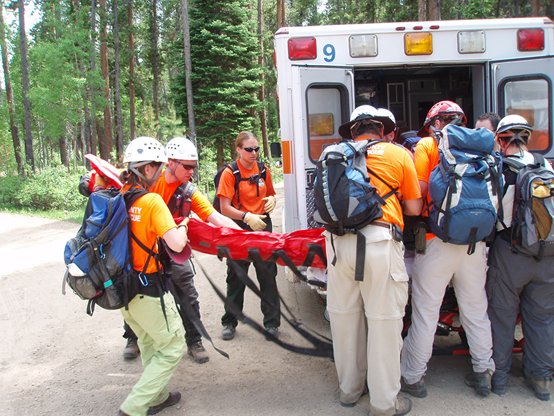
June 22, 2007(Friday)RAWAH WILDERNESS CARRY OUT
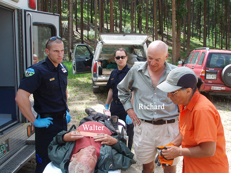
Back to Top82 year old Walter and his dog Taffy are camping at Brown's Park campground, on the east edge of the Rawah Wilderness, about 18 miles up the Laramie River Road and a couple miles south of Glendevey. On Thursday 21 June he decides to hike the Link Trail up to the McIntyre Burn area (if I recall correctly, it burned in the late 1800's). The display board at the trailhead has the following information about the Link Trail: 8.8 miles one way to Rawah Trail, elevation start 8433 feet, elevation net gain 2300 feet; rated difficult. At 10:00 Walter signs in at the trail register, noting he'll be back in the afternoon, hiking the Link Trail, and is camped at site 23. He is the only one listed on the register for the 21st, and everyone on the list for the prior week shows that they signed out, most listing the time they returned. (I took a photo of the register.)
Walter and Taffy make it to the edge of the burn area, and shortly after begin the return hike. Walter wears a small day pack which contains a jacket, water and food, a trash bag and some other items. About four months prior he'd had his right hip replaced, and during the downhill walking it is starting to bother him. He decides to stop and rest by sitting on a large rock and eat lunch. He had a bit of trouble while standing up, and some distance later stumbles and falls on the trail, dislocating his hip in the process. He is unable to get back up, and prepares himself to wait for help by donning his jacket and making the trash bag into an overgarment. Taffy helps by laying down atop Walter. Fortunately, the weather is benign, and remains so during the night.
Simultaneously on Thursday, 62 year old Richard has stopped at the Stub Creek Ranger Station, which is about a mile before the Brown's Park campground. He is talking with the three Forest Service volunteers about local hiking trails and attractions, one of which is the Big McIntyre Burn. He sets up his camper in the campground and reads the brochures they gave him. At 08:25 on Friday morning he signs in at the Link-McIntyre trail register listing his activity as a day hike on the Link Trail. Richard's entry is on the line directly under Walter's entry.
At about 09:30 Richard encounters a sleeping Walter on the trail. Not knowing if the person is dead or alive, he loudly calls out "Good Morning!", which rouses Walter into a groggy awareness of Richard's presence. Richard ascertains that Walter cannot walk, gives him water and a couple oranges, then hastens down the trail and over to the Stub Creek Ranger Station. After they report the incident to LCSO Dispatch, two of the volunteers and Richard hike back to Walter's location, leaving volunteer James at the trailhead to meet responders.
At 10:40 the SAR Manager page goes out, to call Ocean 5, Justin Whitesell. Justin gives me story, and we agree on a direct non-emergency response to the trailhead for LCSAR. In addition, as we have no idea just how stable Walter's condition might be, Justin wants to explore using a helicopter to access and evac him. In between a couple more phone calls between us, and additional pages to the Team, he has the Forest Service contract ship, an Aerospatiale Lama, re-tasked to our rescue incident, and two LCSAR EMT's (Josh Carnes and Denise Alvord) are heading to the Hewlett Gulch helispot. Justin, the PVH ambulance and I also head to this helispot. By the time I arrive, and Denise moments later, the flight crew has been decided as Justin, Josh, and Jared, one of the PVH paramedics. Justin had grabbed the helicopter PPE duffel from Truck 10 to outfit those flying. Justin has coordinates for what he hopes will be a meadow that is very close to where he expects Walter is located, based on his work with the mapping software prior to leaving his office. Denise departs to drive to the trailhead.
However, weather is not looking good in the vicinity of the helispot, showing thickening clouds, wind and lightning. While the helispot manager gives the mandatory safety briefing to the flight crew, I snap a few photos, then depart to drive to the trailhead. Shortly afterward, the skies open up and dump a considerable amount of rain and wind for the next half hour or so, along my drive up to the lower narrows. Upon exiting the narrows, I find the skies are mostly blue and there is little wind. I suspect I'm the last LCSAR vehicle enroute to the trailhead.
Dave Hake is driving Truck 10, and is likely the lead vehicle. Dispatch responds to his request that there are four on the counter and seven that have called in via radio -- a light turnout, though enough for a relatively easy carry to a close helispot, or down a short easy trail -- both unknowns at this time. However, knowing that Richard, the RP, said he hiked up the trail for only 50 minutes before finding Walter, I suspect that the distance will be about a mile, two at the most if Richard is a strong hiker. Also, I know that the two FS volunteers and the RP are at Walter's location, and they could be used to assist the evac if necessary, so I decide to not send out another Team page.
I have driven just a few miles up Laramie River Road when Dispatch advises me that the helicopter cannot fly due to weather, and that Justin and the PVH ambulance are on their way up. A bit later Justin asks if the Team can handle this alone, to which I respond yes, and he returns to town. I've been hearing much radio traffic regarding lightning strikes and smokes, so Justin's talents are better applied today to those potential fires.
Thad Hoff is first to arrive at the trailhead, as he says "about an hour and a half before" others of the Team. (Thad will stay at base, as he has to leave soon for a 17:30 wedding; he's the best man.) Next to arrive at about 13:00 are Dave, Doug Grimm, Scott Evans and Mike Erickson (with Merlin). They form the hasty team, departing at 13:10, with Scott going on ahead to make contact with Walter as soon as possible. Knowing Walter is on the trail, they take the litter, wheel, backboard and vacuum splint, and minimal tech gear for a running belay. The others arriving are Denise, Sarah Babbitt, Bill Daniel, Sandy Jordan, Chad Kline, Jenn Nolte, Larry Sanders and Brian Walsh. Much later Josh arrives, in time to assist with the last 15-20 minutes of the evac. Kim Ruben had car troubles enroute which prevented her from participating. Deputy Earl Fawcett (E-19) stops by to offer assistance, and later brings a cooler of cold well water from the folks at Glendevey, for the evac team's arrival at base.
Scott reaches Walter at 13:50, with the litter arrival at 13:52. Walter is a wiry, leathery, fit person, and the Team quickly transfers him to the vacuum bag in the litter and are on their way down at 14:09. Jenn is designated on-scene medical, the first time for her to apply her RN skills in the field. She does a fine job, and I am able to relay (via Dispatch) a full set of vitals and patient status to the responding ambulance crew. The ambulance arrives about 15 minutes before the litter team, which reaches base at 15:05. Jenn gives her medical debriefing to the crew while the Team transfers Walter to the gurney. When the ambulance crew decides they don't need to keep Walter in the vacuum splint, Jenn and Mike perform a slick removal of it while the others lift Walter clear -- I got a good photo of that move. The FS volunteers will gather Walter's camping items, put them in his vehicle, and keep it at the Ranger Station until he can return. Sandy offers to take Taffy back to town to Walter's wife Diana, and Walter agrees. Richard will stay an extra day and make his Link Trail hike to the McIntyre Burn on Saturday.
In town, Sandy talks with Diana a bit, giving her the details of the situation, and learns that Walter had told Diana that he would be back Saturday or Sunday, and not to worry until later on Sunday. Had Richard not chosen the Link Trail on Friday, Walter could have been in for a long wait ... - -George Janson
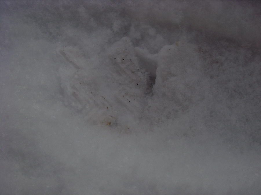
January 2, 2007 Montgomery Pass Search
Back to TopMontgomery Pass SAR Synopsis - - Mark Sheets –SAR Manager - - Larimer County SAR
(map below)n 12/24/06, Trish, a 40-year old Longmont resident told a girlfriend that she intended to go skiing by herself on Christmas Day. Trish did not indicate where she intended to ski. Sometime after the 25th (I believe the 30th) Trish was reported overdue by concerned family members to the Longmont Police Dept. The police put out a “Be On The Lookout” (BOLO) bulletin to surrounding law enforcement agencies but evidently it did not go out to Larimer County until 12/31/06. Her vehicle was located by a Larimer Deputy Sheriff at the Zimmerman Lake Trail Head on 1/1/07. Her vehicle appeared to have been there since the 25th.
It was known that Trish owned two sets of skis, one a Touring model and the other Telemark model. Her Touring Skis were present in her car along with her purse, an ice axe and car keys along with some other articles of insignificance. By the time the SAR Manager got up to the car on 1/1/07, it was around 17:30 hours and dark. LCSO-ES and LCSAR decided to come back to town and plan for the next day’s operational period.
In the early evening of 1/1/06, a some Diamond Peaks Ski Patrollers posted a note on powderbuzz.com, a skiing enthusiasts website describing the missing subject and requested anyone with knowledge to contact LCSO.
Plans were made to search both sides of the road although the terrain that is more suitable for Telemark Skis was a higher priority. By the next morning, a powderbuzz.com lead came in stating that they saw the missing subject at 14:15 hours on 12/25/06, about 3/4 the way up the Montgomery Pass Trail when they visited a short while. Trish indicated she was going up to “make a few turns” then call it a day. The reporting party continued on down to the parking lot where they noticed only their car and Trish’s car remaining. Trish’s ex-husband who has skied with her a lot said her favorite place to Ski was Montgomery Pass.
With these two reports, we decided to not search the Zimmerman side since she was most likely on the other side where the bowls are.
On 1/2/07 at 09:02, 12 LCSAR members, two dogs and 6 Diamond Peaks Ski Patrollers set out to search a fairly large area with a strategy of searching areas that consisted of good Telemark Skiing. Also, many recreators had skied the trails since the 25th so the trails were pretty low probability since she had not been discovered by anyone sine then.
It is known that many skiers enjoy skiing straight down Montgomery Creek and then pop back onto the trail where the creek intersects the trail. There are many other drainages that are attractive to ski.
Most of the Ski Patrol assignments started up in the bowls and continued down into the trees part-way. The LCSAR folks on snowshoes were assigned to start in the middle of the various segments and clear the area back to Hwy-14.
A snowshoe team containing of a tracker was going up-trail and cutting out at 90 degree angles to cut for sign between Montgomery Creek and the Pass Trail. After making a few cuts with negative results, that team finally acquired a single ski track that appeared to be of proper age. The tracks were right in the Montgomery Creek drainage. They continued to track and at 10:35 they came upon two ski poles sticking straight up. A cursory survey the area revealed a tree well that appeared to contain a rudimentary snow cave. They noticed Skis in the tree well and Ski Boots inside the cave along with a space blanket. After searching the surrounding area, the team uncovered the buried body of Trish, she was totally buried by recent snowfall and was approximately 10 feet away.
It is unknown when Trish died and why she was unable to continue to ski out although she may have gotten wet from falling into the tree well and possibly breaking through the ice below in the creek or she may have foundered with an injury. It is also possible that nightfall fell upon her and she may have simply hunkered down. The coroner will be performing an autopsy.
I would like to say thank you to those who responded to this call. It was beginning to take shape of a large search such as the recent Mt Hood incident but with a great team effort from Larimer County Search & Rescue, Diamond Peaks Ski Patrol and Larimer County Sheriff’s Dept. we were able to locate Trish only 1.5 hours after fielding.
Location: Trish was found approximately 1/3 mile from the road. She was so close to being out.